Thursday, July 19, 2012
Sunday, July 15, 2012
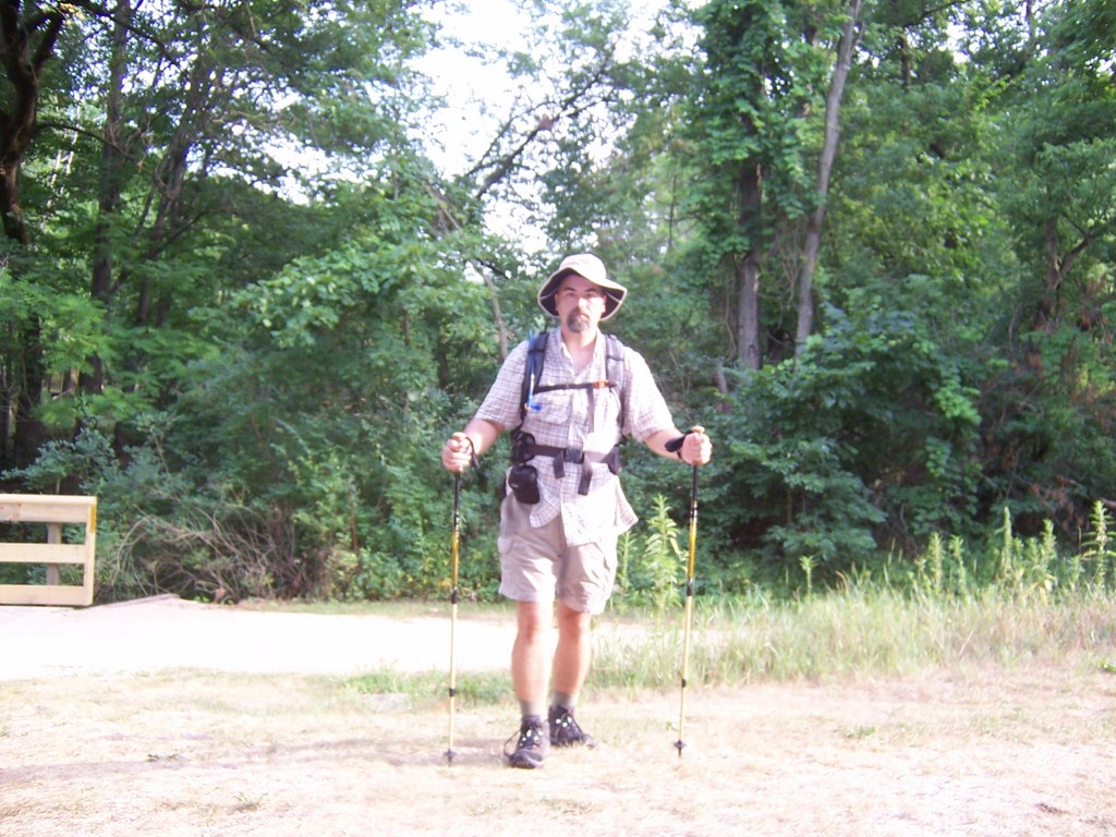
Elroy-Sparta Bike Trail at Norwalk
The kids left on a plane this morning. The wife went back to her weekday apartment. I'm left with a dog, a cat, a fish, and walking up to take care of the neighbors dog. The animals taken care of by 16:00 and I'm on the road.
The goal is to start off from Norwalk and walk the Sparta-Elroy bike trail towards Sparta. I have more of a time limit than a distance limit as I need to get back and take care of a couple of work items before I go to work on Monday. I estimate I have about 3 hours on the trail. There is a particular point in mind I'd like to hit and I might just make it.
I might not, too. The temp is 94F. Most of the country has had a hot dry time of it this Summer. Wisconsin is no different in that regard. Temps in the mid to upper 90's have become the norm the last 6 weeks. Could be 104, I'm still going for hike.
Oddly enough, I'm writing this two days later, the high temp... 104. Didn't go for hike. Instead I spent 45 minutes putting up another section of retaining wall. Took care of the animals and called it all good.
The week before Ruth and I went down to Devil's Lake area and were set to hike a section of the Ice Age trail between Parfrey's Glen and the State Park. Another 100 degree day. We made it up to the end of Parfrey's Glen and on the way back out, on the easiest part of the trail, I rolled my ankle. Rolled it badly. I was able to limp to the car, but my day was done. I'd wanted to hike that section of the trail for two years. I was thwarted by responsibilities once before and now injury.
The ankle was healing, but certainly not healed. 12 days had passed and I'd been walking normally for the last 4. There was still swelling, but the bruising was nearly gone. I'm still going for a hike.
The Sparta-Elroy trail runs from Sparta, WI to Elroy, WI running just over 30 miles. Like the other bike trails in Wisconsin this is an abandoned rail line and is made of crushed limestone.
The Sparta-Elroy trail directly connects to the La Crosse River Trail in Sparta, and the 400 trail in Elroy (ending in Reedsburg). The Great River Trail in Onalaska joins the La Crosse River Trail in La Crosse making an uninterrupted 101 miles of trail through unglaciated river valleys. Spectacular.
I've biked the Sparta-Elroy, Great River, and La Crosse River trails numerous times. At one time the geese that own the trail between La Crosse and West Salem knew me by name. My 13 year old did his first long ride of his life (70 miles from our house to the Sparta trail head and then all the way into La Crosse.) He mentioned the geese. Those geese are tough, they are possessive, and they have guarded a 100 yard section of the La Crosse River trail for over 40 years.
Norwalk is a small agricultural village just Southeast of Sparta. Dairy, church, and a couple bars (with most excellent burgers – either of the places are great to eat at). There isn't much to Norwalk and frankly that is just perfect.
I left the parking lot at 16:48. The sun was still high. The trail moves through open pasture and crop land. Luckily the trail is bordered by a thin line of large trees on either side. Off the trail the temp is 94. On the trail the temp is 84.
Peaking through the trees, the view is quintessential Wisconsin farm land. One side is a corn field stretching to bluffs a half mile away. A county road winds through the middle. The other side is pasture strewn with large sand stone boulders, an oak tree here and there, and cows. Many cows. Then the view switches. Now the pasture is on the right side and soybeans on the left.
 |
| Coulee countryside |
About two miles in, the trail passes the Tri-Creek Watershed flood control dam and Norwalk Lake. The Norwalk Rod and Gun Club uses the dam as a back stop. Glad no one was at the range today.
The trail has been climbing, gradually, since leaving Norwalk. Makes some sense as the creeks from Norwalk Lake need to flow downhill to get anywhere. The grade is not noticeable at all, but shortly after passing the lake I look up ahead and find that I am in the middle of a long hill.
The landscape has changed a bit as well. The corn and beans are largely gone. The bluffs have tightened closer to the trail. Pastures share the land with more trees and are often heavily sloped. The cows need to be more goat than bovine.

A little break area is about 3 miles down (up?) the trail and has a small one room museum. This is worth a stop. I'll describe that in a bit more detail later.
Shortly after the break area the trail changes dramatically. The steady, but slight incline continues. The bluffs defines the trail as it enters a canyon. The temperature drops dramatically and everything is wet. This part of Wisconsin has seen less than 1/8" rain since mid June, yet the trail is almost mud. Streams line each side of the trail and the high rock walls drip water. After 400 yds the reason for this comes into sight... Tunnel #1.


The Sparta-Elroy Trail sports three tunnels along it's 32 mile journey. Tunnel #3 is the longest of the three at almost 3810ft (over 2/3 mile). The temperature drops signficantly upon entering the tunnel, eventually leveling off into the mid 50's. The tunnel is wet. Very wet. Puddles are everywhere. Water runs steady along both sides and the water cascades down the sandstone sides of the tunnel.
Not that you are going to see any of this. The tunnel has no lights. In Tunnel #3 there is a point where the is no light behind and no light ahead. Pitch black.
Many people go into the tunnels without lights. Many go through just fine. Nearly everyone walks their bikes. Some ride through. They get hurt. My advice: bring a light and walk your bike.
I had my Tikka head lamp on, for all the good it did me. The fog in the tunnel was as thick as I'd ever seen it. Past three feet and there was nothing to see. The walk was slow.
 |
| Halfway through! |
My turnaround point was the other end of the tunnel. This would give me an 8mile round trip hike, a good hike for the time allotted. I missed that by about 50 ft. I met two bikers entering the tunnel without lights. They'd already tangled amongst themselves twice in 50ft. I offered to lead the way through the tunnel. They readily accepted. I regaled (bored) them with what I knew about the building of the tunnels, the tunnel watchmen. All of this I learned years ago at the neat little one room museum already described.
The way back was the same as the way forward. I stopped at the museum and ate a powerbar and took in a some water. I hit the tunnel at 17:49 (an hour in) and came back out the tunnel at 18:12. I made the museum by 18:22. I usually break every hour, but there just hadn't been an appropriate spot until getting out of the tunnel.
Gnats. They swarm me. I mentioned that in an earlier post. While hiking I'd have to swat off a gnat or two every couple minutes. No problem. I'd already thought ahead and when I stopped for a break I brought out the no-see-um head net. Worked like a champ. I could see the dozen or more gnats crawling on the net. I could hear a few of the buzzing, trying to get in my ears. Nah, nah, nah, can't get in!! I'll be sporting that on future hikes for sure.
One thing I do need to learn when wearing the net is that food does not go through the net. It must go under!
I left the museum at 18:30. The hike back was quick and uneventful save that milking time must have been at hand. The cows were making quite a fuss. Their mooing could be heard across the entire valley. Only maybe a quarter mile from one of the barns the sound of the cows could have been next to my shoulder. I was back to the parking lot by 19:38. Took a bottle of water and dumped it over my head. Threw out the garbage I collected along the way and drove away back to the animals.
I was very happy with the hike. The ankle was not noticeable except in the tunnel where the trail is dotted with potholes filled with water and the edge drops off sharply in the darkness (Hemingway would have been proud of this sentence).
The bike trails can get boring as they are not narrow footpaths that wind through forest. They don't have switchbacks crawling up the side of a mountain. They are generally flat and travel through farm land and towns. Still, each of the trails has unique features, such as bridges, tunnels, rivers and streams. The trails, in cutting across the dairy land show what rural Wisconsin is really like, how people live in this part of the country.
Whether by bike or hike, these trail systems are a blessing.
8 miles in 2hrs 50min.
Update::: Two weeks later my friend William and his 6yr old boy walked with me from Norwalk through the tunnel and to the parking area on Kenya Ave, a little over 4 miles. A much cooler evening and having two cars we were able to hike one way. That was a good hike and was to great to have William along. I think his boy will come away with quite a story of cows and tunnels.
Update::: Two weeks later my friend William and his 6yr old boy walked with me from Norwalk through the tunnel and to the parking area on Kenya Ave, a little over 4 miles. A much cooler evening and having two cars we were able to hike one way. That was a good hike and was to great to have William along. I think his boy will come away with quite a story of cows and tunnels.
Sunday, May 20, 2012
Black River State Forest - Smrekar Trails
The Black River State Forest of Wisconsin offers a variety of outdoor activities. The most notably is hunting, but a close second is the ATV trails. In the Winter there are a set of cross country ski trails. These trails work very well as hiking trails in the Summer. They are not frequented as hiking trails. Except, of course, by me.
http://dnr.wi.gov/topic/StateForests/blackRiver/
GPS Track
Millston is the very popular entry point to the Black River State Forest. The Pigeon Creek Campground, ATV trailhead, and two ski/hiking trail systems are a couple miles to the East of Millston. There is gas and food as well.
On a cloudy day in late May I took the 45 minute drive North to Millston and parked at the trailhead for the Wildcat Mound trails. Directly across the road is the back side of the Smrekar trails. I've hiked Wildcat a couple times, the most notable on a neat little Winter hike two years ago. Made a hibernating porcupine angry. I'd only hike about 1/2 mile of the lower Smrekar trails back in Fall of 2010. Today I would tackle most of the trail system.
The two trail systems are divided into 7 different loops. Wildcat, Red Oak, Norway Pine, North, Central, Ridge, and South. They pretty much describe themselves. There are three connector trails for a couple of the loops.
Map and literate can be found at : http://dnr.wi.gov/forestry/publications/pdf/FR-168.pdf
My path today would take me from the Wildcat parking area to the North leg of the North Loop, the Ridge trail, the West part of the Central loop, and then back to the parking lot.
I locked the car at 14:32. The sky was threatening thunderstorms. I doubted whether to come at all, but I just had to get out on the trail. The need to get sweaty, dirty, and bitten by bugs was just too much. The temps earlier in the day were mid 80's but now had dropped down into the mid 70's. A fairly stiff wind blew from the West. A storm was coming. The first half mile was all through pine plantation and I had my rain jacket at the ready.
The map, as expected in these loggable areas, does not show every path. About 15 minutes in a recently used path cut across the trail running East to West. I was expecting an intersection soon, but this was not it.
At 14:55 I'd made the intersection to the Ridge trail. The intersection is really more of a "two paths in a wood diverge" kind of intersection. Stay LEFT!
To this point the trail has been flat. Shortly after the intersection, though, I was suprised to find myself in the middle of a climb. The trail winds along the side of a bowl and continues to climb. Just when you'd expect to start leveling, the trail turns and continues to rise.
By 15:15 I was walking along a very narrow ridge. The ridge snaked along with a few PUDs (pointless ups and downs). I institued a mandatory 10 minute tick check. I'd already pulled four of those nasty creatures off my shoes and leg in the last 10 minutes.
I must digress here. I hate ticks. I vote to eradicate them entirely. I don't buy into any notion they play a role in the ecology except to sicken and kill people and animals. The predators they do have should be shamed and beaten for such a poor showing of skill. Ehrlichiosis is a dangerous disease caused by ticks. I came down with that in 2011. I was very very sick. You cannot heal yourself with this infection. You need drugs. You need medical care. You need a wife that can handle the pressure of seeing her husband pass out on the way to urgent care. Yeah. Fevers that last 8 hours and subside for only two. Muscle cramps. That's the good part. The bad part is Doxycycline. Some people can handle that drug ok. Some people, like me, need the car pulled over so they can vomit on the side of the road.
I hate ticks.
Up on the ridge the wind was a bit fierce. Taking a break on a bench with an overlook I had to secure my backpack. The wind was enough to blow it off the bench. The good news is that with the wind the gnats and mosquitoes were practically non-existent. Well, not practically, but I wasn't killing them left and right.
I hate gnats. They don't bother some people. They bother me. The last two years (2011-2012) I've not been able to step outside for more than 3 or 4 minutes without being swarmed by gnats. I do not exaggerate this. Swarmed - 3 to 4 minutes. I've had a canoe trip nearly ruined by gnats.
The view from the ridge was dark. Although no rain had come to me, the sky was a dark dark gray. In the distance I could see bluffs obscured by rain. The storms were out there only a few miles distant.
The wildlife was not very abundant along the Ridge trail, but I suspect the high wind played a factor there. The woods had long ago transitioned from pine to mess of Oak, Hickory, etc that make up the bulk of the Black River State Forest. Heavy undergrowth. I was able to get a good picture of butterfly on tree. That'll make the wife jealous. I had to wait 5 minutes for the little guy to decide to settle down.
![]() The intersection of Ridge and Central came along at 15:56. A few mintues later the intersection of Central and South was passed. I declined to do the short South loop today. Save that for another trip. Once off the Ridge the trail is once again a flat, flat, flat, wide ski and mountain bike trail. By 16:03 I went through the Smrekar parking lot. The bathrooms were being cleaned by a rather unfriendly lady. Decided I could tinkle in the woods rather than disturb her job. I've done the janitorial thing before. I wasn't too happy then either.
The intersection of Ridge and Central came along at 15:56. A few mintues later the intersection of Central and South was passed. I declined to do the short South loop today. Save that for another trip. Once off the Ridge the trail is once again a flat, flat, flat, wide ski and mountain bike trail. By 16:03 I went through the Smrekar parking lot. The bathrooms were being cleaned by a rather unfriendly lady. Decided I could tinkle in the woods rather than disturb her job. I've done the janitorial thing before. I wasn't too happy then either.
The West part of the Central trail has a mix of pine plantations and some younger fir trees. Naturally, the ubiquitous oak and hickory as well. The forest along this stretch is shorter. Probably logged about 10 years ago.
Along this stretch the sky became very dark, the wind dropped off, and the temperature dropped 10 degrees in a few minutes. Out came the rain jacket again... and for nothing. The rain simply refused to fall. No, wait, here it comes, spit, spatter, nope. Not going to rain.
The reduction in wind allowed the birdsong to be heard. The crows earned the day, though. A young crow was clearly upset about something.
I'd only taken one 10 minute break and it was time to do so again. At 16:30 I sat down on a stump just off the trail. A large part of the inner of the Central loop had recently been logged. Likely done so last Summer or Fall. Not every tree was taken down and not all that were downed were taken out. I've seen clear cut areas before and this did not quite qualify. Perhaps 90% of the tree cover was harvested, but enough stood to still provide a forest feel. The view opened up giving a feel to the lay of the land. I'm not entirely sure what to compare this to. I had some notion of the feeling I've had when break into the sub-alpine in the Cascades. No, not quite that. The effect was very interesting. The picture I took does not do justice to the scene.
Tick number 12 crawling on the stump. Tick 13 and 14 on my boots. Time to move along.
I was not hiking particularly fast today, nor was the terrain overly challenging. The Ridge trail provided some short climbs and some PUDs, but overall this was an easy hike. Still, I was pooped after just a couple hours on the trail.
At 17:24 I unlocked the car. 6.78 miles in just under 3 hours.
http://dnr.wi.gov/topic/StateForests/blackRiver/
GPS Track
Millston is the very popular entry point to the Black River State Forest. The Pigeon Creek Campground, ATV trailhead, and two ski/hiking trail systems are a couple miles to the East of Millston. There is gas and food as well.
On a cloudy day in late May I took the 45 minute drive North to Millston and parked at the trailhead for the Wildcat Mound trails. Directly across the road is the back side of the Smrekar trails. I've hiked Wildcat a couple times, the most notable on a neat little Winter hike two years ago. Made a hibernating porcupine angry. I'd only hike about 1/2 mile of the lower Smrekar trails back in Fall of 2010. Today I would tackle most of the trail system.
The two trail systems are divided into 7 different loops. Wildcat, Red Oak, Norway Pine, North, Central, Ridge, and South. They pretty much describe themselves. There are three connector trails for a couple of the loops.
Map and literate can be found at : http://dnr.wi.gov/forestry/publications/pdf/FR-168.pdf
My path today would take me from the Wildcat parking area to the North leg of the North Loop, the Ridge trail, the West part of the Central loop, and then back to the parking lot.
I locked the car at 14:32. The sky was threatening thunderstorms. I doubted whether to come at all, but I just had to get out on the trail. The need to get sweaty, dirty, and bitten by bugs was just too much. The temps earlier in the day were mid 80's but now had dropped down into the mid 70's. A fairly stiff wind blew from the West. A storm was coming. The first half mile was all through pine plantation and I had my rain jacket at the ready.
The map, as expected in these loggable areas, does not show every path. About 15 minutes in a recently used path cut across the trail running East to West. I was expecting an intersection soon, but this was not it.
At 14:55 I'd made the intersection to the Ridge trail. The intersection is really more of a "two paths in a wood diverge" kind of intersection. Stay LEFT!
To this point the trail has been flat. Shortly after the intersection, though, I was suprised to find myself in the middle of a climb. The trail winds along the side of a bowl and continues to climb. Just when you'd expect to start leveling, the trail turns and continues to rise.
By 15:15 I was walking along a very narrow ridge. The ridge snaked along with a few PUDs (pointless ups and downs). I institued a mandatory 10 minute tick check. I'd already pulled four of those nasty creatures off my shoes and leg in the last 10 minutes.
I must digress here. I hate ticks. I vote to eradicate them entirely. I don't buy into any notion they play a role in the ecology except to sicken and kill people and animals. The predators they do have should be shamed and beaten for such a poor showing of skill. Ehrlichiosis is a dangerous disease caused by ticks. I came down with that in 2011. I was very very sick. You cannot heal yourself with this infection. You need drugs. You need medical care. You need a wife that can handle the pressure of seeing her husband pass out on the way to urgent care. Yeah. Fevers that last 8 hours and subside for only two. Muscle cramps. That's the good part. The bad part is Doxycycline. Some people can handle that drug ok. Some people, like me, need the car pulled over so they can vomit on the side of the road.
I hate ticks.
Up on the ridge the wind was a bit fierce. Taking a break on a bench with an overlook I had to secure my backpack. The wind was enough to blow it off the bench. The good news is that with the wind the gnats and mosquitoes were practically non-existent. Well, not practically, but I wasn't killing them left and right.
I hate gnats. They don't bother some people. They bother me. The last two years (2011-2012) I've not been able to step outside for more than 3 or 4 minutes without being swarmed by gnats. I do not exaggerate this. Swarmed - 3 to 4 minutes. I've had a canoe trip nearly ruined by gnats.
 |
| View from Ridge Trail |
The wildlife was not very abundant along the Ridge trail, but I suspect the high wind played a factor there. The woods had long ago transitioned from pine to mess of Oak, Hickory, etc that make up the bulk of the Black River State Forest. Heavy undergrowth. I was able to get a good picture of butterfly on tree. That'll make the wife jealous. I had to wait 5 minutes for the little guy to decide to settle down.

The West part of the Central trail has a mix of pine plantations and some younger fir trees. Naturally, the ubiquitous oak and hickory as well. The forest along this stretch is shorter. Probably logged about 10 years ago.
Along this stretch the sky became very dark, the wind dropped off, and the temperature dropped 10 degrees in a few minutes. Out came the rain jacket again... and for nothing. The rain simply refused to fall. No, wait, here it comes, spit, spatter, nope. Not going to rain.
The reduction in wind allowed the birdsong to be heard. The crows earned the day, though. A young crow was clearly upset about something.
I'd only taken one 10 minute break and it was time to do so again. At 16:30 I sat down on a stump just off the trail. A large part of the inner of the Central loop had recently been logged. Likely done so last Summer or Fall. Not every tree was taken down and not all that were downed were taken out. I've seen clear cut areas before and this did not quite qualify. Perhaps 90% of the tree cover was harvested, but enough stood to still provide a forest feel. The view opened up giving a feel to the lay of the land. I'm not entirely sure what to compare this to. I had some notion of the feeling I've had when break into the sub-alpine in the Cascades. No, not quite that. The effect was very interesting. The picture I took does not do justice to the scene.
Tick number 12 crawling on the stump. Tick 13 and 14 on my boots. Time to move along.
 |
| Logged area of Central loop |
At 17:24 I unlocked the car. 6.78 miles in just under 3 hours.
Monday, April 2, 2012
Spring Is Here
The warm weather actually hit in March. March 21st and the trees started to bud. 10 days later, no foolin', and only the birch have yet to bud. Our magnolia has blossomed and the blossoms are nearly completely dropped.
Did get out for a very very short couple of hikes in the last week. One in the backyard woods for about a mile. Part of the trail borders the backyards of three houses across the street. One neighbor cleared out a bunch of scrub that blocked his yard from the trail. Think I'm going to have to blaze a new trail that goes off into the woods a bit in that area. There is no less than 6 feet from the trail to his lawn and only two or three bordering trees. That's too close for comfort. I don't care for hiking through people's yards.
The second hike/walk was with the wife and youngest boy. About three miles down a snowmobile trail on the east side of town. One day I'll need to put on the pack and walk that trail for a few miles. Follows an old railroad grade for miles. Through an industrial area, a subdivision outside town, farm fields, and beyond. Looks interesting.
The wife bought me a willow tree for our 5th anniversary. Put that into the ground last week. Sure hope we don't get a freeze in April. Spring is just way too early. Disorienting.
Next chance for hike is looking like this Thursday, April 5th. Depends, though. I'm very anxious to put the canoe in the water. Only so much daylight. Between work and kids, there has been precious little free time.
Plans for the summer? Well, I'm hoping to be able to get a good sized hike in over by Lake Michigan. Don't what yet and it will involve the wife and kids. With the kids that discounts a day long hike. They just haven't the patience to put up with that kind of discomfort. Another one is that I'm really hoping the wife and I can put in a good 15 miles or so on the Ice Age Trail up in Merrill in August. Big trips are kind of out this year, and probably the next. The money is just not there and won't be for a few years. Work's not sending me anywhere so no opportunity in foreign lands either.
Sorry folks, this blog might just get a little boring for a few months. Never can tell, though. I would have never guessed I'd been to the places I have in the last five years.
Monday, February 13, 2012
Green Swamp West - Florida
I had had great misconceptions about the opportunity for hiking in Florida. Even after having read "50 Weird Hikes" by Art Bernstein I still did not quite comprehend the outdoors of Florida. I understood the Everglades, the beaches, the waterways that whorl around coastal islands. I did not appreciate the open country of the Florida swamps. Miami, Ft Lauderdale, Jacksonville, Tampa, Orlando, Ft Meyers cover the landscape of Florida with man made structures, the false nature of golf courses, gardens, and fruit groves, but in between all of these are thousands of acres of swamps and grasslands. I'd never taken a close look at the map of Florida before, but when I did I saw the tracts of green between the scars of silver.
Probably the last big vacation we'll take for a few years put us in Orlando. No, Disney and the theme parks are not our speed. The Kennedy Space Center was more like it. If you have a single drop of geek blood and have not been to the Space Center, shame on you. Don't wait like I did.
One of the days, of course, had to be set aside for a hike. I pretty much refuse to go on vacations that don't include hikes in the woods, mountains, or swamps. Based out of Orlando, there are several choices, but the one that seemed to be the most remote within easy driving distance is the Green Swamp Wilderness Preserve of Florida.
At 110,000 acres Green Swamp the Green Swamp comprises 5 tracts of land including Colton State Park. Fishing, camping, hiking, biking, horse riding, boating, paddling and hunting are the main activities in the Green Swamp. The Florida National Scenic Trail cuts diagonally across the preserve.
The West Tract (http://www.swfwmd.state.fl.us/recreation/areas/greenswamp-west.html) offered us a good set of hiking trails within just a little over an hour drive from Orlando. We made our way to the Mc Neil Entrance off CR 471. From Orlando take I-4 to exit 32 and take US 98 N. Follow th e highway through populated areas. After some time you'll pass by Central Florida Paintball. Stop if you must, but otherwise keep on the highway. The highway heads sharply Northwest at this point. Just after Gator Creek Campground you'll pass by Rockridge Rd. This also offers some entrances into the Green Swamp, but keep going. Eventually you'll see the signs for CR 471 and a right turn to head straight North. I do mean straight.
After 4 miles a parking lot for Colton State Park will be on the left. Next comes a small bridge crossing and then immediately on the left is the McNeil Entrance to Green Swamp West. The trail starts under the arch, but is riven over by a firebreak. Walk the firebreak South for about 30 feet and the trail heads off into the wooded swamp land.
 |
| Lot and Entrance |
This Winter has been nearly devoid of appreciable rainfall in Florida and the results were easy to see in the swamp. The trail and path were very dry. The palm fronds, though green, were tough and sharp. The trail was liberally peppered with dry leaves. Sneaking up on the egrets in the small pond was impossible. Still, not all of them flew away at our approach.
Within twenty minutes of being on the trail we were treated to different creatures found in the swamp, wild pigs and egrets. The pigs came out of nowhere on the trail Two black spots 15 feet in front of us. Mama and baby stood by the trail for only one or two seconds, long enough for us to figure out what we were looking at. Then they were gone into the low palms that covered the swamp.
The egrets were something we caught out of the corner of our eyes. Just a little bit of white that seemed out of place. About 100ft off the trail was a small pond. On the other side were a dozen or more of these specimens. One my favorite things about paddling the backwaters of the Upper Mississippi are the heron and egrets. Eagles are great. So are owls and hawks, and cardinals, and...

We briefly caught an owl flying past us later on. Heron made appearances along the way as well. I almost stepped on a toad. Had Stefan not been looking I would have squashed the poor thing hiding under leaves.

The day was proving to be an excellent one for hiking. The temp topped out around 67F with almost no wind and no clouds. That is right inside my wheelhouse.
The trail winds along past water holes, many of them bone dry. We kept imagining what animal life would be here in a rainy month. No alligators today.
The trail crosses a dirt road several times, a few times the trail followed the road. We had to be sure to look for the trail signs as it exited back into the vegetation. The trail was very well marked and at no time on the trail did we wonder which way to go. A little different on the way back, though.

The trees kept my attention. I didn't really know what kind of trees I was looking at. Clearly some of them were a type of fir, some a type of oak, and yes, ever present are the palms. Often we walked through patches where long white strands of moss draped down large trees. I was simply fascinated by how beautiful these were.
Almost halfway through the hike we came across three cactus plants growing right by the trail/road. Both plants were small and stayed nearly flat to the ground. They each covered only several inches of the ground. We saw no other cactus anywhere on the trail that day.

A little more than 3 miles in we hit the "troll" bridge and our turn-around point. We had one kid waiting back at the hotel and it would be dark in three hours. Our plan was to make the bridge and head back. Naturally, my hope would have been for a 12 to 15 mile day in the swamp. Hit the trail at 8am and get off the trail before the sun left the sky. But... had to moderate that desire with other's willingness and the fact I wasn't on vacation alone!! So, back we went. My back was in really bad shape nearly the whole time we were there, especially this day. So, turning back was probably good for me too.

We re-traced our steps for the first couple miles. At one point we decided to take the road instead for a change-up. The trail crossed the road in several places. We were sure we'd pick up the trail again down the road. We were not patient enough and decided that we must have gone past the last place the road and trail met. Despite having a GPS we were worried about travelling to far South and having to backtrack. With dark only 2 hours away we took a cross road that went directly East. The GPS showed we were still North of the trailhead, so we had no worries. Either this east-bound dirt road would intersect the trail, or we'd hit the highway and half to hoof it for a half mile on pavement. East we went.
Glad we did. We saw a bit of eco-diversity. On the left side was a swamp that had recently undergone a controlled burn. The right side was the swamp untouched for a few years. Being able to compare the environments close at hand was interesting.
 This road never did intersect the trail. When we hit the highway we were greeted by five foot high barbed fencing. We were also greeted with the firebreak that lead us back to the McNeil lot. Hiking the firebreak was rough going. Basically, a machine comes through and plows up the ground making a five foot wide swath of dirt.
The total hike was about 6.5 miles, a short one. Still, a great experience of the swamp land of Florida in a pair of boots. I'd certainly go back again, but the hike would have to be longer. Someday.


Sunday, January 15, 2012
First Snowshoe hike of Winter
FINALLY!!!
Three days ago we received our first substantial snowfall of the Winter. This Winter has been brown and dry; November lasting 10 weeks. Temperatures had at times been in the 50's and 60's. While some folks liked this I was restless for snow.
I used to cross country ski when I was younger. I may try it again, but I have a feeling my left leg and hip aren't going to be all that good for that. Downhill ski is something I've only done twice and have no desire to do. At this point, with my balance and conditioning, I'm sure to break something important.
Last year I splurged and bought a good pair of snow shoes. I had them out 6 times last Winter, three of them in the woods around our house.
That's what I did today. A little 1 mile-ish loop on a couple of trails right from our backyard. About 8:15 I hit the snow and walked out into the woods. About 4 to 6 inches in most places and except for where the neighbors tuned up their snowmobile and another neighbor took the back way home, there were no human made tracks. The sun was not yet visible as it sits low in the sky and is obscured by the ridges to the South and East, but daylight was full. About 20F and almost no breeze.
Besides a hawk and a couple of sporadic twitters, the wildlife was silent. Tracks were plenty. Deer, dogs, maybe coyote?, rabbit, mice. No raccoon tracks today.
I had to take a 5 minute break and pull briars out of my pants about halfway through. Hooked my right shoe on something, tried to yank it free, but whatever hooked me won that battle and down I went into a patch of undergrowth.
When I first picked up the shoes I talked to the gal behind the counter about her shoeing experiences. One thing she mentioned stuck out. "Expect to fall. Everybody falls. You'll fall the first time you're out and many times after that."
I logged about 8 hours between the first three times I went out. I hadn't fallen once and I'd not strictly stuck to the trails. You can't stick to the trails as the trails are typically ski trails. You shoe on ski trails at your own risk. You'll leave the woods with a ski pole in at least one orifice.
Not once did I fall.. until the 4th time out. The day before the SuperBowl last year Ruth took her skis and I took my shoes. She skiied the trails and I tromped through the woods. We figured we'd link up on the prairie after about 45 minutes and parallel each other back to the parking lot. Just before we were to link up I was climbing a small incline through a stand of pine. One of the shoes got hooked and I fell forward into the snow and undergrowth. No big deal, but I really banged my right knee hard. Wow, that hurt. Figured I'd have a good bruise from that.
I met up with Ruth about 5 minutes later to make the last mile back to the lot. I was definitely hurt. I was having visions about how purple that large bruise would become. How swollen. The pain was about a 6 on the pain scale. I trudged my way through the rows of corn stalks, falling twice more!!
Well, figured I'd be off my feet for a day or two. In reality I had no idea of what was to come.
Back at the parking lot we stowed our gear and I figured I'd better take a look at the knee. There was a dime size hole through my outer pants. Then a dime size hole through my long johns. Yes, there was a dime size hole in my knee. Something had stuck right through two layers of pants and into the synovial space between the patella and femur. "Wow. Hey Ruth. We should go to the walk-in."
The rest of the afternoon was spent at the ER. X-Ray, wound irrigation, and a shot of antibiotic. Another pair of crutches. Wrapped it up and figured I should be good in about 6 to 8 days.
The next morning the knee looked pretty ugly. The wound was starting to close, but there was a little bit of red around the wound. Quite swollen. I watched the SuperBowl running a 102 temp. We went into the doctor the next morning. Short story... massive infection that spread up my entire thigh. Spent two nights in the hospital and missed a week of work.
Just one of those things.
The weeks later I was back in the snow shoes and back on the trail. And today I fell... again.
Sunday, January 8, 2012
Hills of Onalaska
GPS Track
January 8th, a rare weekend off for Ruth. We saddled up the boys and headed to Onalaska to find a couple of geocaches. Well, we were 1 for 2 on the day. Couldn't find a micro and we scoured the area. Cleverlly hidden indeed.
We've had an odd Winter. Temperatures in the 50's and 60's. No snow for Christmas this year, a real bummer.
This day was in the low 40's and sunny. Again, a day I'd expect in November, not early January. Still, it did allow the whole family to get out and slink about a ridge that lies to the East of Onalaska.
I had always wanted to get out and hike around these hills. Between highway and commercial area and a residential subdivision lies a 1200ft high ridge that runs about 3/4 North to South and about a half mile West to East.
The ridge is dotted with several trails and is heavily used by the hundreds of households in the subdivision in the valley. Trail access is found at the end of Alpine Pl in an empty lot between two houses. We didn't do so, but in the future I'll consider parking down by the park and walking the extra 1/4 mile. I can imagine that having a whole pile of cars parking outside your house can be a little bothersome.
The subdivision is quiet and while on the East side of the ridge the highway sounds are greatly muted. This makes for a nice little urban escape.
This ridge was not always so urban. I came to the La Crosse area in mid 1990. At that time what is now Apsen Valley was populated with a few houses. At the end of the valley was a big red barn (which is still there). Beyond the barn was corn, hills, and trees.
Today, the view to the West of the ridge is a great view of Menards, subdivisions, and finally the Mississippi. In 1990 Menards was not there and only half the houses between the ridge and river were there.
 A real history lesson comes from my wife Ruth. She grew up a mile from these hills. Many hours were spent in the hills and valleys that are now homes and businesses. She hadn't been back in these hills since her childhood, decades ago. There were few houses between the ridge downtown Onalaska. There were only a handful of homes at the South end of the Valley. That area was square miles of swamp, hills, and forest. Ruth spent her free time hiding in the caves, making campfires, and just wandering the woods.


January 8th, a rare weekend off for Ruth. We saddled up the boys and headed to Onalaska to find a couple of geocaches. Well, we were 1 for 2 on the day. Couldn't find a micro and we scoured the area. Cleverlly hidden indeed.
We've had an odd Winter. Temperatures in the 50's and 60's. No snow for Christmas this year, a real bummer.
This day was in the low 40's and sunny. Again, a day I'd expect in November, not early January. Still, it did allow the whole family to get out and slink about a ridge that lies to the East of Onalaska.
I had always wanted to get out and hike around these hills. Between highway and commercial area and a residential subdivision lies a 1200ft high ridge that runs about 3/4 North to South and about a half mile West to East.
The ridge is dotted with several trails and is heavily used by the hundreds of households in the subdivision in the valley. Trail access is found at the end of Alpine Pl in an empty lot between two houses. We didn't do so, but in the future I'll consider parking down by the park and walking the extra 1/4 mile. I can imagine that having a whole pile of cars parking outside your house can be a little bothersome.
The subdivision is quiet and while on the East side of the ridge the highway sounds are greatly muted. This makes for a nice little urban escape.
This ridge was not always so urban. I came to the La Crosse area in mid 1990. At that time what is now Apsen Valley was populated with a few houses. At the end of the valley was a big red barn (which is still there). Beyond the barn was corn, hills, and trees.
Today, the view to the West of the ridge is a great view of Menards, subdivisions, and finally the Mississippi. In 1990 Menards was not there and only half the houses between the ridge and river were there.


Subscribe to:
Posts (Atom)