Welcome

Welcome!
I've been absent from making posts, but the hiking has continued. 2015 is coming to a close and there are many stories to tell from the last two years...

2015
---------
Oh wow. Many many hikes. Ice Age Trail, Colorado, South Dakota Badlands. I need a week off work to do some writing.

2014
----------
July 21st - Sam Baker State Park, Missouri
August - Paddling Door County
Sept 7th - Ice Age Trail - Mondeaux Segment
Oct 3rd - Levis-Trow
Oct 18th - Ice Age Trail - Greenbush Segment

Wednesday, August 15, 2012

Ice Age Trail - Turtle Rock Segment


     The Turtle Rock segment of the Ice Age Trail is found about 15 miles North of Merrill, WI and makes use of both County and private land.  Still within Northern Wisconsin this segment is part of the Ice Age Trail that is mostly trail with only a few road segments.

     Merrill sits on the Wisconsin River and is surrounded by the absolute beauty of Northern Wisconsin.  I will take the risk of alienating a whole part of Wisconsin but, for me, Northern Wisconsin starts at Hwy 29.  Merrill is a couple dozen miles North of HWY 29.  Travelling North, I-39/US 51 passed by Lake Du Bay and Eau Pleine Flowage.  The highway continues North past Mosinee, but just after Mosinee a large ridge is crested and the view to the North is of a series of tree covered ridges dominated by Rib Mountain.  HWY 29 is only a few miles away and the Wausau area begins the Eastern part of Northern Wisconsin, just as Chippewa Falls begins the Western part.  My opinion, but if you ever do take that drive you’ll see well how my opinion is formed.

     Merrill is a historic small town of around 10,000 souls.  Much in keeping with a River town there are few streets in Merrill that are actually straight for more than a few blocks.  The new round-about is confusing and ill-used, making driving a pull behind camper a real treat. 
     The history of Merrill is dominated by the logging industry that once owned every square acre of Northern Wisconsin.  My first wife’s grandfather grew up in Merrill and, as a teenager,  worked in the lumber camps in the early 1900’s.  He also boasted the first personal automobile in Merrill with his family making a living as one of the few blacksmiths in town.  When I’m in Merrill I’m ever aware of the history and people, Melvin’s stories come alive for me.
     In 2000 I was part of the GRABAAWR (Great Annual Bicycle Adventure Along the Wisconsin River).  Our stop after Day 2 was in Merrill.  The first day went from Eagle River to Minoqua.  That first day started with thunderstorms and ended trying to sleep in the hallway of a high school with 1100 other wet people, the humidity of wet clothing, and the sound of the electric hand dryers working overtime in the bathrooms.  Day 2 started out from Minoqua with absolutely fantastic weather; temps in low 70’s, mostly sunshine, a light Westerly breeze.  The ride was along the river and sported nearly constant views of the lakes, streams and rivers along the way to Merrill.  My trip partner and I stopped at GrandFather Dam, one of the many dams along the Wisconsin River.  In Merrill I had great pizza, got my bike fixed at the bike shop (who worked overtime when 1100 bikers rode into town).  After two days of riding 30% of us had some kind of issue.  I once again attempted to sleep in high school hallways.  Ah, yes, great memories.

     Merrill was also the location of the sectional cross country meet in 1986 that sent my team to the state competition.  Yeah, I like Merrill.

     Two years in a row my wife and I have come up to Council Grounds State Park in Merrill to camp while we go the Big Bull Falls Blues Festival.  Yes, one of the highlights of the festival is having one of the bands lead vocalists try to say that 10 times fast.  The music is great, the food is awful, the scenery is spectacular.

     This year we went up a couple days early with the camper.  One of the main features of the camping trip was to tick off another segment of the Ice Age Trail… the Turtle Rock segment.

     As is typical when hiking with my wife, the start time is greatly delayed.  Most avid hikers understand that and early start is a good start.  There are several reasons:
-          Earlier in the day is cooler
-          Earlier in the day has more bird song
-          If you get lost you have more daylight with which to ponder your fate (or find a nearby road, or get un-lost)
-          Earlier in the day is just plain the way it’s done, alright?!?

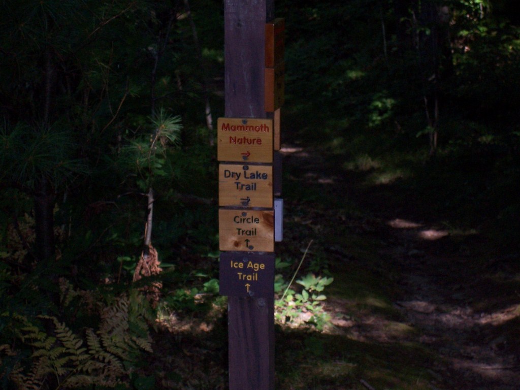
     So, at 12:47 we walked across Cty Hwy E parking area to the trail head.
Trail Head on Cty E - sharing a snowmobile trail

     The first mile is already a treat.  The sky is nearly cloudless and the temperatures are in the upper 70’s.  Considering the 90 and 100 degree temps Wisconsin has dealt with this Summer,  temps in upper 70’s are nearly Arctic.  The trail in this first mile moves from foot trail to snowmobile trail, to foot trail, to dirt access road, back to foot trail.  The first mile travels through stands of poplar and hemlock, then through some older growth and a bog before beginning a slow descent towards the river.
Trail - the first mile

The Bog


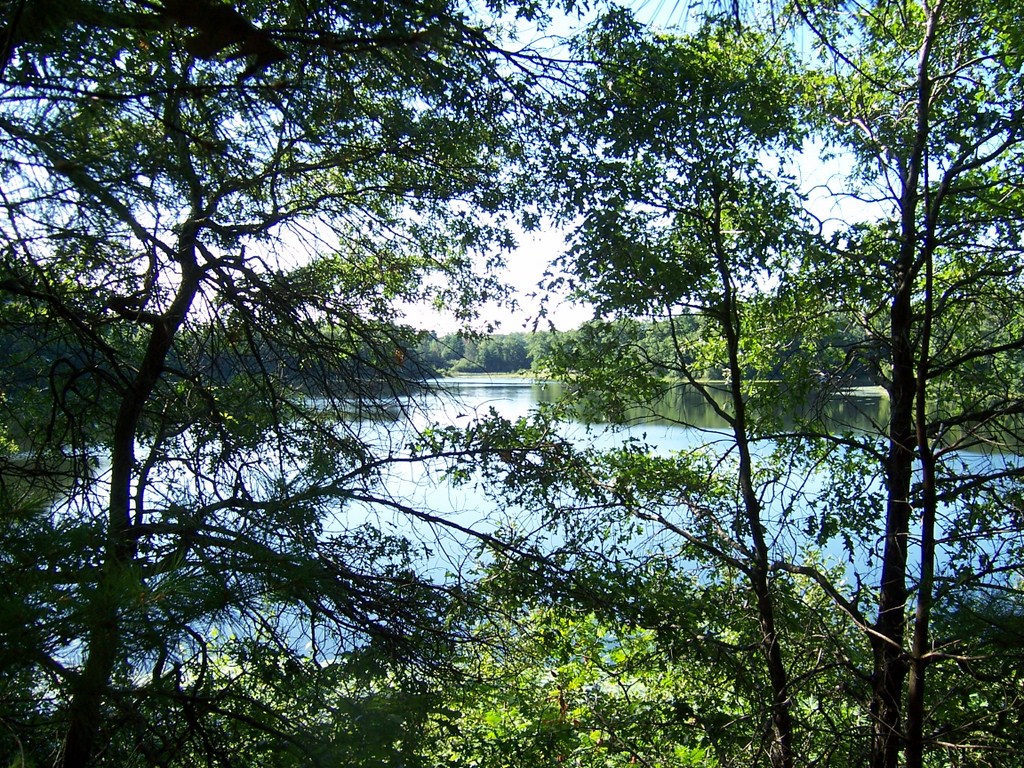
The trail, a footpath now, winds along the side of  a steep hill, hanging just above a small creek.  At 13:24 we were at the spot where the creek, and trail, meet the Wisconsin River.  A few minutes later Ruth simply sat down at the side of the trail and without fanfare we took our first break.  The trail was literally three feet from the river’s edge.  She could not have picked a better spot for a break.  Much of the trail as it approached Grandfather Dam tightly hugged the river.  There were several obvious fishing spots along the trail.  This is definitely a part of the trail that might be nearly impassable in the Spring.  The River need only rise less than a foot to completely flood the trail in most spots. 


Trail along creek leading to Wisconsin River

Break on the River

     At 13:47 we hit Grandfather Dam.  This is a small dam, like many along the river, and there is not much to see on this side.  There are some rocks to climb along and a little down the way there were a couple of families playing out in the water or on the big rocks out in the water.  Ruth seemed more motivated to push on, so after about 45 seconds of standing the dam wall, we were off.
     The falls is not for from the dam.  We could hear it as we passed.  I asked twice if “we” wanted to head off the trail out on the rocks and see if we could see the falls.  “That’s OK.  Let’s keep going.”  No falls this trip.

     The trail to dam was easy, even when it was a foot path.  No hills to speak of, only a gradual downhill.  Smooth and even with a very easy stream crossing at the bog.  That all changes after the dam.
 
     The landscape by the river after the dam is a series of boulders, smaller rocks and arms of high land.  The trail winds up short but steep fingers of land, then falls quickly into valleys that would be a swamp in wet weather.  When the trail is not on land, it is going through, around, and over boulders.  The ground between the boulders is only inches thick.  Water trickles in the hollows between rock and dirt.  This is a very rugged and relatively challenging section of the trail.  Be sure your boots are laced up good and your ankles are ready.

Near Grandfather Falls

Rocky trail along Wisconsin River

     After a half hour and one false climb, the trail makes a real climb up out of the river valley, climbing 165 feet very quickly with only two switchbacks.  Soon, though, the climb is over and lands at series of logging roads and foot paths.  The guide recommends bringing map and compass and at least the map is very useful in this part.  There are several trails and logging roads that lead off in different directions.  Pay particular attention to the yellow blazes.  There are a few spots where it is easy to veer off the trail.

     We took a 20 minute break in a small clearing along a logging road at 14:55.  This was a good chance to get some food, get the packs off, and dry myself off.  I just have to say that I applaud the advent of quick dry materials.
     We listened closely about us for birds and also tried to identify threes.  Sadly, there was very little bird song and our tree identification suffers still.  We did get a chance during our long break to watch some butterflies play, but were not able to capture a good picture.  At the campground, though, we were treated to bald eagles flying directly above and dipping down to the river to catch fish.


     After about 15 minutes more of walking on a series of foot path and other paths, the trail joins a well-used dirt access road.  This rest of the trail section, about a mile, continues on this easy path until it reaches Burma Rd.  Just as we entered this last section we met our first person of the hike (well, we saw, but did not meet the people on the river.  They never saw us, being warned not to feed the wildlife.)  He was a section hiker like us.  He has a goal of hiking all the trail sections of the Ice Age, but has no intention of hiking the connector routes unless they are useful.  Interestingly, he uses his bike as a shuttle so that he would avoid backtracking and thus cover more trail.  I’d done the same at the Chippewa Moraine a week earlier.

The Way Out

Trail Head on Burma Rd.


     We hit the end of the trail and Burma Rd at 15:49.  We now had two miles of pavement to cover back to the car.  The first mile, Burma Rd, was gravel, but Cty E is paved heading East from the intersection of Burma Rd (heading West it too is gravel).  Finishing a hike on pavement seems to be a ritual.  I'd really like to know how many hikers experience this.  I've done it to make it back to parking areas, to catch the bus, and to make it home.
     By 16:07 we’d hit Cty E and pavement.  At 16:32 we arrived at the car.

     The total trip or 7.13 miles took 3h 50m.  Another great Northern Wisconsin adventure was complete.


Saturday, August 11, 2012

Ice Age Trail - Chippewa Moraine Segment

Link to Ice Age Trail Alliance
Link to Chippewa Moraine Reserve


     The Ice Age Trail is Wisconsin's contribution to long distance hiking.  This 1100 mile walking path starts in Interstate State Park in far Northwest Wisconsin and ends at Peninsula State Park in Door County, dipping as far South as Janesville.  Some will say the trail starts in Peninsula State Park and ends in the Northwest.  The trail guide has the route going that direction, but the maps start their numbering at Interstate State Park.  That makes following the guide and maps a bit interesting.
     A majority of trail, particularly in the Central and Southern parts of the state runs along county highways and rural roads.  These detract only slightly from the grandeur of the trail because when the trail is dirt, the trail is a gem.

     The Chippewa Moraine Segment of the Ice Age Trail runs generally West to East (or is it East to West) from a gravel road to a boat landing.  The Ice Age Trail itself runs for 7.8 miles, but with other trails in the area it is possible to put on several more miles.  There are also some gravel roads to explore if your time and feet are allowing more miles.
     The trail runs through the Chippewa Moraine National Scientific Reserve.  The Reserve has a visitor's center that sits on top of a walled lake plain.  What's a walled lake plain?  Let's consider that homework.  Visit the Reserve and find out.  You won't be disappointed with your visit.

     I started looking at the Ice Age Trail a few years ago.  My wife bought me an atlas of the Ice Age Trail.  I brought it with on a vacation to Northern Wisconsin.  We never made it to a trail that was part of the Ice Age Trail and worse... I left the atlas at the cabin.  In the last several months I've felt that hiking sections of this trail was something that was going to be important to me.  The trail goes through some of the most engaging scenery in the Midwest and some of the segments are only a couple hours drive away.  A day trip!
     The two closest areas that are largely on trails and not roads are the Devil's Lake segment near Baraboo and the Chippewa Moraine Segment North of Bloomer.


     I left the house at 06:10 and heading North through Black River Falls on Hwy 27.  Picked up the Interstate there and continued to Eau Claire where I picked up Hwy 53 to Bloomer.  Drive through Bloomer on Hwy 40 to County M. 
     What an absolutely gorgeous morning.  When I let the dog out at 05:30 the temp was about 52F and the sun was just breaking the trees.  Not a cloud.  Along the drive to Black River Falls, HWY 27 runs along a couple of high plains.  Looking out to the East are several coulees and some higher bluffs.  The sun splashed across the corn, soybeans, trees, and the coulees were covered in fog. 
     Traffic was light the entire way to the Chippewa Moraine.  I could not have asked for a prettier day to hike in Northern Wisconsin.  I do not have the vocabulary to describe the joy I felt through the whole day.
I arrived at the visitor's center at 08:15.  The center didn't open until 08:30 and I thought I'd wait.  I wanted to see if they would hold my pack while I dropped the car and biked back.  Since the back surgeries I find bike riding to very uncomfortable.  The left leg and hip cannot handle the position and hills hurt far more than they should.  Still, I thought I could manage 30 minutes of biking the rolling terrain.  I was able to drop my pack with the staff.  They were more than happy to help.  I left the car at Plummer's Lake about 08:45.  The temp must have been in the low 60's which was the only comfortable thing about being on a bike again.  County M passes a couple lakes (little lakes are everywhere in this part of Wisconsin. In one of those lakes I saw a deer standing knee deep getting a drink.  The camera was in my pack.  I tried to remember my shifting strategies I'd learned when I used to bike all the time.  Not sure I did so well, but by 09:15 I was back at the center and only somewhat in pain. 

Outside Visitor's Center
Trail Start
     I began the hiking portion of this adventure at 09:30, following the Circle Trail to the West.  The Ice Age Trail runs with the Circle Trail for a little more than a mile before it splits and continues running West.  Along the way the trail runs up and down small hills and winds it's way around lakes.  I was nearly beside myself with good humor.  I know why I felt this way.  I usually do feel that way when I'm in Northern Wisconsin.  The feeling never gets old.
     Some of my best memories are in either from being in Northern Wis (and Northern Michigan) and some simply about Northern Wisconsin.  When I was young, 10, 11, 12, I used to watch the Saturday Late Late Movie on the NBC station out of Eau Claire.  Movies back then were something a kid could watch without being scarred and warped.  The movie started at 22:30 and usually went until 1.  I normally fell asleep around 23:15.  I only remember one movie ( Jody Foster played an 11yrd old with a terminal heart condition.  It was a sad movie, Echoes of A Summer.  I believed for 15 years that the movie took place at a lake resort in up-state New York.  Fitting, right?  Yeah..., an ocean bay in Nova Scotia is the actual location.  Anyway... all of the commercials during those movies were for the tourist traps and commerce bureaus of the towns in Northern Wisconsin.  Lots of pretty pictures of sun dappled lakes, fluttering birch leaves.  That struck a chord with me.  I spent most of my summer days in the fields and woods on the out-skirts of Marshfield.  Catching frogs, building dams, building forts.  Then we went on a family vacation to Rhinelander and camped at a scout camp.  We hit the usual tourist traps like Jim Peck's Petting Zoo.  I saw that sun dappled lake and fluttering birch leaves first hand.  I was sold.  Then came a few years of scout camp at Rhinelander as a Boy Scout, vacations as an adult in Eagle River, Bayfield, Cable, adventure racing in Northern Michigan, bicycle tour along the Wisconsin River.  Since leaving college I've been able to go back to those lakes and trees almost every Summer.  That dappling, man that dappling.  It's for real.  It really exists and it's got me good.


North Shattuck Lake
      Today was simply a perfect day to be in the woods up North.  Temperatures in the upper 60's to mid 70's with a cool breeze from the Northwest.  Hardly a cloud in the sky.  Not a chance of rain.
I ran into a couple camping along the Ice Age Trail.  They had hiked in from 267th Ave, set up camp for a night with their doggie (a lab of some kind).  They were just breaking camp when doggie decided he needed to meet me.  Shortly after that I met another couple.  They stopped to ask directions.  They had walked to the end of the Ice Age Trail at 267th Ave.  After a minute or two I was able to get from them what they had intended to hike.  Basically, they wanted to hike the Circle Trl starting from the center, heading East.  The trail goes in a Circle (hence the... yeah).  Trouble was, they started out going West.  Got them re-oriented and was somewhat comfortable they knew what direction to go when they hit the intersection.
     I hit the intersection about 20 minutes earlier, around 09:56.  By 10:25 I made it to 267th Ave.  I dropped my pack for a few minutes, drank some tea I'd packed along and took a short break.  At this trail head there is a little plaque that describes the history of a stump.  Some day this stump will completely rot and fall to nothing.  I hope the plaque remains.  I'd mentioned summer camp memories of Northern Wisconsin, and this stump is all about that.  The stump was once a tree that bowed over the gravel road and was called the Chippewa Bay Tree.  This tree grew in an arc over the road and was an important landmark for the kids arriving at Chippewa Bay Camp.  The tree was considered the entrance to the camp and is still an important memory for many who are no longer young, except at heart.  I'm almost in tears thinking about this and writing it down.  I'm verklempt.. talk amongst yourselves...  Topic... archealogical reconstructionism.


Stump on right is what's left of Chippewa Bay Tree
      We're back.  A five minute break, just enough time to take in the history of the spot.  This is the only part of the hike where I backtracked.  I met the camping couple on their way out (and doggie too.)  By 10:53 I was back at the intersection for the Circle Trail.  Rather than follow the trail back to the visitor's center and then pick up the Ice Age Trail, I had planned to take the Circle Trail South and then pick up the Ice Age Trail when they meet on the other side of the Circle Trail.  This meant that I would actually skip about a mile of the Ice Age Trail in this segment.  The purists be damned.  The South Circle Trail was spectacular.
Good gravy.  I'm writing this and listening to Pandora.  "Sunshine on My Shoulder."  Yeah, wow.  You know, I wish that when I was younger I had appreciated his music as I do now.  He was gone far too early for me.

     The South Circle Trail runs between a couple lakes and then runs South of North Shattuck Lake.  There is also a South Shattuck Lake and a North Of North Shattuck Lake.  Check the map.  I'm not kidding.
The maps shows there to be no lakes South of the trail for a bit, but there are lakes there.  I went through the Circle Trail parking area and crossed Hwy M at 11:05.  Shortly after that I spotted a chipmunk on the trail about 30 feet ahead.  That's pretty close for chipmunk to let a person near.  The chipmunk is my spirit guide.  That is yet another Northern Wisconsin story I have.  I'm always trying to spot those little critters.  I tried for five minutes to get a picture, but he was very good at playing hide and seek.
The trail is a small roller coaster nearly the entire way.  Climb 20 feet up, then drop 15, then climb 10, drop 10, climb 30, drop 20.  All the while climbing and dropping with peeks of small lakes through the trees.  Birdsong in the trees and the wind through the leaves.  Yeah, an occasional car, motorcycle, or small airplane too.  The trail is in Wisconsin, not Northern Alberta.


Along the Circle Trail

     At 11:35 I took a break on a bench overlooking another un-named lake.  This one appears on the map. (45.213470, -91.416322).  I needed a more substantial rest.  My legs were getting tight and I'd stumbled a couple times over rocks and roots.  I need to get off my feet.  At this point I had the woods to myself and sat on the bench, stretched, ate part of a peanut butter sandwich and just took in the view of the lake.
Did I mention that I was having just a great time?

Break-time Lake

Sunshine on the Circle Trail
      I was back on the trail after fifteen minutes.  The intersection with the Ice Age Trail was only a little bit ahead.  The trail passed a lake at (45.216823  -91.405635).  The lake is not on the map, but that didn't stop a family of loons from living there.
     At 12:12 I picked up the Ice Age Trail and immediately ran into two college age guys.  They were dropped off at the visitor's center (about a mile up the trail the other way) and were on their way to spend a week on the trail.  They'd never really been hiking like this before.  They picked a good day for a start and I sure hope they have a couple more days like this before they get hit with rain.  We've had an incredibly HOT Summer this year.  Temps in the upper 90's and into the 100's were the norm.  No rain, except way up North where it flooded.  Had they been hiking in those temps they would have been a bit challenged.  Maybe not, they're young.  We played leapfrog for a little bit as I stopped to take a picture or listen for an animal, but eventually my pace outdistanced theirs.  I carried 15 pounds.  They carried 40.

     Walking along the Eastern shore of Dam Lake I heard a loon call.  Once.  Then twice, then a third time.  The call was not from Dam Lake.  I could see most of the lake and the sound was carrying from some other lake.  South?  East?  Could not tell.  I stood for a minute or two to try and catch another call, but the concert was over.  Three acts.


The Love Mushroom!!   Just sitting in the middle of the trail.
      After heading Northeast along the shore of Dam Lake the trail takes a U-Turn and heads Southeast rolling up and down small hills.  The bottoms were dry but only due to lack of recent rain fall.  One good rain and the trail would be under a foot of water.

Along the Ice Age Trail

     The trail squirts between Horseshoe Lake and a couple of un-named lakes before reaching Town Line Rd.  A wooden walkway provides access over drainage between Horseshoe Lake and one of the un-named lakes.  The walkway provides a very picturesque view of both lakes.  A narrow peninsula that helps make the Horseshoe in the lake looks like a small island from the trail.  Frog calls come from the Southern side of the peninsula.
     Before reaching this walkway I ran into a two hikers.  Naturally, they asked where I was hiking and when I described where I'd parked the woman exclaimed, "So, you're the one!"  I was off to bad footing here.  Apparently I'd driven up to the boat landing just as the male in the couple had given the all clear for the woman to act like a bear in the woods.  She saw me clearly and assumed that I'd seen her.  I did not and tried to assure her of that.  It was clear she wasn't much in to having me near them.  Interestingly though, she is a member of the trail association for that segment and has worked on keeping that very trail clear.  She did mention that she enjoyed working on the trail and hearing the stories of the Ice Age thru-hikers (the 1000 milers).  I talked with her friend a bit, but it was pretty clear from her that I should move on.  Maybe I read something wrong, but I really got the feeling she didn't like me.  And me without my light sabre.  I saw them one more time and the guy talked to me a bit about water filtration.  I'd stopped for a short break on Town Line Rd; just to get the pack off and hydrate a little better.  He asked if I'd stopped to get water from the lake and that set off a short conversation on filtration techniques.  The guy has hiked in many many places across the country.  I stayed a couple minutes ahead of them for the remainder of the hike (a little over a mile) and was packing up when they arrived at the boat landing.  I would like to have talked more, but I just got bad vibes from the woman.  As I sit here writing I have some regret that I didn't try to engage her in conversation, but you go with what you think you know at the moment.

     What I believe to be the most breath-taking spot on the trail is just past Town Line Rd.  Crossing Town Line Rd the trail continues up a small wooded hill and then opens up into a ice walled lake plain.  The plain sloped from the top of a hill all the way down to Dumke Lake.  This late in the season only some of the wildflowers are still in bloom, primarily the goldenrod and aster.  Cone flowers were hit hard by the abnormally hot temps this Summer and are pretty much done for the year already.  The plain was still stunningly beautiful. 
The trail goes through a fence, through a pasture with real moo cows.  Then around the North side of Plummer Lake and to the boat landing.  All done. 


Dumke Lake and Plain
      I think of it now, but I should have counted the lakes that I went by and rated them a size.  That would have been interesting I guess.  I did miss about one mile of the actual Ice Age Trail by taking the South Circle Trail, but I'm glad I did.  I saw the loons, heard others, and ran into two groups of hikers I otherwise would have stayed ahead of.

Absolutely fantastic hike and my first segment of the Ice Age Trail completed.
GPS say 9.91 miles.  Watch says 4h30m.

Wednesday, August 8, 2012

Hayling Island - Havant/Portsmouth UK


     The first week of August 2012 brought me back to Havant, UK and Hayling Island.  Work brought me here two years ago and work brought me here again.  The last time I was here for nearly two weeks.  The only free time I had then was a weekend.  Long days at the facility and longer nights working at the hotel.
     This time around the trip was much shorter and far more relaxed.  I ended up with a free Monday and made my way into London.  Summer 2012 was an Olympic Summer and London was the host.  I was unable to procure any tickets to events, but I did have a good time taking a walking tour of Westminster. 

     I took the train into London, which is not the cheapest.  An all-day pass from Havant to wherever was around $80.  At the Waterloo station in London I had to switch over to the underground to get to Piccadilly Circus station.  That was pretty interesting.  Waterloo is a big station, both national rail and the underground tube all come through Waterloo.  Something like 24 rail platforms and 6 underground.   And it is underground to be sure.  Way underground.  Twist and turn, go through three different gates.  But it's reasonably well signed.  Like the saying goes when hiking the mountains… route finding skills are necessary.

    The idea was to walk from Piccadilly to Hyde Park where there was an Olympic venue. I planned to just poke around and obtain some souvenirs.  Then, at 11:00 go on a free walking tour of the royal buildings in Westminster (including my wife’s favorite Big Ben).  Right off the bat I had a problem.  I had neglected my camera at home.  I was left with my phone for pictures, but the camera app froze on my phone.  I pulled the battery, put it back in and found that the battery was almost completely out of charge, despite having plugged it into the computer all last night.  Well, duh... the computer goes into sleep mode.  When that happens, the power to the USB ports goes off.  I was asleep by 19:50 last night and got up at 06:30.  So... no power to the phone and no pictures of London.

    The next problem was that the Olympic venue at Hyde Park did have a souvenir shop, completely on the other side of the park.  I'd never make it to the end of the park and back in time.  After the tour?  Sure, if I hoofed it.

     The tour was really worth the time.  Free was a bit of a misnomer because the guides are not paid.  Therefore donations are "appreciated."   I had expected that and the cost was really not much.   An energetic 20 year old aspiring actress was our guide.  She clearly loved history, particularly of the royal family, and was a great guide.  The best was the story of Irishman Michael Fagan.  That is an excellent campfire story.
     I was the oldest on the tour by 10 years.  Most of the 14 people were under 22.  One woman from LA was 33, another from Albany NY was 28.  Everyone else was under 22.  Half the group was from the US, with two guys from Germany, three guys from different places in South America, two girls from Canada (whom we lost about 3/4 through the tour.  They were with us at Trafalgar Square and then they weren't).
      The tour took us past Buckingham palace where we saw a little bit of the changing of the guard.  There were far too many people to get a real view of it, but saw some stuff.  We walked past St James cathedral, Westminster Palace (where Big Ben lives), Westminster Abbey.  A brilliant tour.

     The tour was supposed to end about 13:45, but it went about an hour long.  That was perfectly OK, but made it impossible for me to get to the end of Hyde Park and back to a station that would get me back to Havant with enough time to shower and get to work.   On the way back to the station I saw signs on a roadside souvenir shop that said "London 2012."  No Olympic stuff, at all.  That can only be sold that at the venues themselves.  Souvenirs would have to wait until the airport.

     Rain threatened the whole day, but only a few sprinkles hit us.   A very nice day all in all with the temps around 74 for a high, partly sunny.  To see London, you'd need three days.  One day for the royal buildings, one day for old London (London bridge, Tower, etc.), and another for museums.

      Between walking and the undergrounds, things in London are closer than you think.  However you need to be willing to walk several miles in a day.

     Tuesday was a work day, but I was back to the hotel by 16:30.  That still allowed about 2 ½ hours of daylight.  Naturally, I went for a walk.  The Langstone Hotel is at the very North end of Hayling Island about 400m from the Hayling Island bridge.  The Island is about 6 miles long and at the North end about 600m wide.  The island grows wider as the further South.  At the North end is the Langstone Bridge connecting the island to Havant.  At the Southwest end is a ferry to Portsmouth.  Two years ago I took the train to Portsmouth and then walked from the Naval Shipyard to the ferry, up the entire length of Hayling Island to the hotel.  I figured that to be around 12 miles. 

     The estuary between Havant and Hayling Island is tidal.  At one time there was a stone walking path through the middle, before there was a bridge.  Some of the stone markers are still in place.  The walk to the bridge from the hotel is along a very narrow footpath.  A shallow ditch covers most of the 1m between the path and road.  Nothing covers the space between the footpath and water.  I really do enjoy the walk back and forth to the facility.  A good way to start and end the work day.

     Back to the walk.  This was a short walk.  I left the hotel without a rain jacket.  Not the smartest thing to do while in the UK.  Especially that day.  The clouds were heavy and within 5 minutes there was a drizzle.  Within 15 minutes there was a steady rain.  I turned back.  I would come back tomorrow.


     Hayling Island has a few walking paths or footpaths.  These handfuls of paths take you around and through the Island.  The North part of the Island is the Marina, hotel, and a Texaco.  There really isn’t room for anything else.  The middle of the Island is farm and pasture.  The population is on the South end of the Island.  Though, like so many places in the UK there really is not wilderness (except very very far North).  The paths follow narrow roads and farm fields for the most part.  There is a more established bike and walking path on the West side.  More on that later.

Estuary outside hotel

      The work day ended early and I was able to walk out the front of the hotel at 16:00.  Boots on, phone charged (for pictures), and rain jacket in hand I started down Northney Rd heading South.  The last two decades have had a few cartoons set in UK (i.e. Wallace and Grommet) and rabbits seem to be overly plentiful.  These cartoons are not exaggerating by much.  Across the road from the hotel is a horse pasture and as I walked past that fenced in area a rabbit convention was underway.  At least 30 rabbits covered that clovered field.
     The sky threatened rain with dark, low, gray clouds.  The temperature was somewhere around 60F.  Actually, not a very bad afternoon but I was glad to have remembered my rain jacket this time.

    Northney Rd, at this point has no sidewalk and each lane is wide enough to contain most of the body of the typical small cars found in Europe.  Straight is not a word one would use for this narrow paved path. 
     Within 7 minutes I’d reached Northney village, a smattering of houses along the East side of the road.  Each was a small house with low stone walls and front gardens.  Their front view across the road was horse pasture, replete with horses.  One of the foot paths leaves the road just before Northney and heads west along the fence line between two of those pastures.  I stayed with the road, listening closely for approaching traffic and making ready to step off into the bushes. 
     Most inhabitants of the homes had just made their way from work and were busy moving from car to house or tending to plants.  I walked by without garnering so much as a glance.  I had to chuckle at that practiced indifference.  I nearly always draw at least a look.

Approaching Northney

Northney Farm


     Around two or three bends in the road a small red barn comes into view with a vine covered sign declaring Northney Farm.  The farm is a garden market with tea rooms and was unfortunately closed at the time or I would have stopped by.  The setup is very quaint with the barn a mere three feet from the road.  Vines, flowering bushes, and white wood fencing separate the gardens and grounds from the passing vehicles.

     At 16:20 some light sprinkles welcomed me to St Peter’s church.  My trips to Europe have made me very aware of the short history of the United States.  We are proud of being able to claim letters from relatives in the Civil War, but St Peter’s church was built in 1140AD.  This church still operates as one of the two churches on Hayling Island.  The grounds of the church are full of headstones, most of which have been wiped clean of any engravings by centuries of wind and weather.


     The path I was to choose today leaves the road in the church yard.  Actually, the path left the road was back in Northney but I missed the turn and followed the road.  I was glad of that or I’d not have seen Northney Farm and a little more of Hayling Island living.  On the North and South side of the grounds the trail walks through wooden gates and into fields.  The South exit follows a foot path for 200m and then joins a dirt farm road heading west.  The dirt road cuts a straight line through wheat fields turned a golden brown with stalks at times as high as my shoulder.


     Ten minutes of walking along this road, listening to the litany of crows fighting over left overs, the farm road turns right and heads south.  At this point a marker declares this to be the site of an old Roman temple.  This was also the site of an Iron Age shrine dating back to around 700BC.  This site is now recently cut wheat field populated by dozens of birds.
Site of Iron Age then Roman temple


     This is also a split point for the footpath.  One footpath continues to head west along the field while the other turns south continuing to follow the farm road.  My original plan was to head down the South path until it too turned west about 400m.  As I walked down the path it became apparent the turn was going to bring me right through a farm yard.  In fact, it would bring me right between crop storage buildings where four men were working with heavy equipment.  I suppose that I would have been fine to have walked right by with a smile and wave as this is an established and supported walking path.  Being from the US with the dangers of walking on private property well entrenched, I turned around and took the West path at the site of the old temple.
     The path leaves the farm road immediately and is simple a moderately used line of dirt skirting a ditch and field before becoming a three foot wide space between barbed wire fence and bushes.  A few minutes of walking in this corridor the path goes over a fence and into a horse pasture.  As I approached the horse pasture there was a middle-aged couple with their two horses was just leaving on the other side.  A sign on the other side of the pasture relates that this is a public field where people will bring run their horses and dogs.   I took care to distinguish between the clumps of sodden dirt and biologically processed horse food.
Footpath

     Having crossed the field I was now on a residential street and pavement.  The short stretch of Northwood Ln ends at Havant Rd.  The time now was 16:55 on a Wednesday and commute hour was in full swing.  A short walk North on Havant Rd comes to a pedestrian cross-walk across the road.  A sign for the Nature Preserve precedes the cross-walk.  If you miss the sign on the East side of the road, take note to watch for a “Thirst-Aid” store on the West side.  The entry to the preserve follows an alley between houses.  Be sure to use the button to activate the crossing light or you’ll have to wait a couple hours to cross the road.  The cars come from both directions with no let-up.
      The 200m long alley ends at gravel walk way that skirts the shoreline.  Portsmouth is in full view across the bay.
View of Portsmouth from Hayling Island

     This gravel and dirt walk way is known as Hayling Billy Trail and covers most of the distance from North to South along the West shore.  The entire area of the trail is a seashore nature preserve.  The trail is well frequented by locals and tourists alike.  Although not crowded there are nearly always people within view or hearing. 

     The sky quickly began to clear and the promised rain never came but for some sprinkles in a graveyard.

     The trail curves along the shoreline through thickets, thistles and flowers.  A few side paths wind along willows that provide excellent meeting places for teenagers.  Brushing through a stand of some kind of flowered stalk I walked square into a great dane and his 12 yr old master.  The dog, as you might imagines, met the shoulder height of his human counterpart.

     The trail also travels by the old oyster beds.  Hayling Island had been, at one time, a hub for salt and oysters.  The oyster beds are now part of a nationally protected wetlands as they are nesting and migration site for some type of rare tern. 
     The oyster beds also played an important role during WWII.  Portsmouth has been an important naval shipyard since the British deployed a navy.  The Germans were quite keen on destroying Portsmouth but never succeeded.  One small part in that lack of success was using Hayling Island as a decoy.  The lights in Portsmouth would be turned off and Hayling Island would be lit up like the larger Portsmouth would have been.  The oyster beds were lit such that could pass for a ship yard.  The Germans were seldom fooled and very few bombs ever fell on Hayling Island.  At the same time the Luftwaffe were confused enough that they generally missed Portsmouth altogether.
Oyster beds... or Portsmouth Naval Shipyard?

Hayling Billy Trail

     At 17:30 I reached the end of the trail and took a seat on a stone bench for a few minutes to soak up what little warmth the sun was providing.  Now at the North end of Hayling Island again the walk to the hotel was only 5 minutes.
End of Hayling Billy Trail / Langstone Bridge

     I never can say where work or pleasure will take me, but I have had the opportunity to be on this little piece of historic Europe twice now.  The North side of Hayling Island has a unique feel.  In that short bit of island there are wheat fields, horse pastures, farms, houses, tidal shoreline, historic churches, and a takeout Chinese store with pretty lousy orange chicken.  If I should chance to be here again I need to leave the North end to sleeping and explore the South side of the island. 

      I need to pass along my sincere gratitude to my hosts at Lockheed Martin in Havant.  Bob, Paul and the rest of team have been very friendly and helpful partners in both my visits.  I very much hope to see you again whether for business of pleasure.