Link to Chippewa Moraine Reserve
The Ice Age Trail is Wisconsin's contribution to long distance hiking. This 1100 mile walking path starts in Interstate State Park in far Northwest Wisconsin and ends at Peninsula State Park in Door County, dipping as far South as Janesville. Some will say the trail starts in Peninsula State Park and ends in the Northwest. The trail guide has the route going that direction, but the maps start their numbering at Interstate State Park. That makes following the guide and maps a bit interesting.
A majority of trail, particularly in the Central and Southern parts of the state runs along county highways and rural roads. These detract only slightly from the grandeur of the trail because when the trail is dirt, the trail is a gem.
The Chippewa Moraine Segment of the Ice Age Trail runs generally West to East (or is it East to West) from a gravel road to a boat landing. The Ice Age Trail itself runs for 7.8 miles, but with other trails in the area it is possible to put on several more miles. There are also some gravel roads to explore if your time and feet are allowing more miles.
The trail runs through the Chippewa Moraine National Scientific Reserve. The Reserve has a visitor's center that sits on top of a walled lake plain. What's a walled lake plain? Let's consider that homework. Visit the Reserve and find out. You won't be disappointed with your visit.
The trail runs through the Chippewa Moraine National Scientific Reserve. The Reserve has a visitor's center that sits on top of a walled lake plain. What's a walled lake plain? Let's consider that homework. Visit the Reserve and find out. You won't be disappointed with your visit.
I started looking at the Ice Age Trail a few years ago. My wife bought me an atlas of the Ice Age Trail. I brought it with on a vacation to Northern Wisconsin. We never made it to a trail that was part of the Ice Age Trail and worse... I left the atlas at the cabin. In the last several months I've felt that hiking sections of this trail was something that was going to be important to me. The trail goes through some of the most engaging scenery in the Midwest and some of the segments are only a couple hours drive away. A day trip!
The two closest areas that are largely on trails and not roads are the Devil's Lake segment near Baraboo and the Chippewa Moraine Segment North of Bloomer.
I left the house at 06:10 and heading North through Black River Falls on Hwy 27. Picked up the Interstate there and continued to Eau Claire where I picked up Hwy 53 to Bloomer. Drive through Bloomer on Hwy 40 to County M.
What an absolutely gorgeous morning. When I let the dog out at 05:30 the temp was about 52F and the sun was just breaking the trees. Not a cloud. Along the drive to Black River Falls, HWY 27 runs along a couple of high plains. Looking out to the East are several coulees and some higher bluffs. The sun splashed across the corn, soybeans, trees, and the coulees were covered in fog.
Traffic was light the entire way to the Chippewa Moraine. I could not have asked for a prettier day to hike in Northern Wisconsin. I do not have the vocabulary to describe the joy I felt through the whole day.
I arrived at the visitor's center at 08:15. The center didn't open until 08:30 and I thought I'd wait. I wanted to see if they would hold my pack while I dropped the car and biked back. Since the back surgeries I find bike riding to very uncomfortable. The left leg and hip cannot handle the position and hills hurt far more than they should. Still, I thought I could manage 30 minutes of biking the rolling terrain. I was able to drop my pack with the staff. They were more than happy to help. I left the car at Plummer's Lake about 08:45. The temp must have been in the low 60's which was the only comfortable thing about being on a bike again. County M passes a couple lakes (little lakes are everywhere in this part of Wisconsin. In one of those lakes I saw a deer standing knee deep getting a drink. The camera was in my pack. I tried to remember my shifting strategies I'd learned when I used to bike all the time. Not sure I did so well, but by 09:15 I was back at the center and only somewhat in pain.
 |
| Outside Visitor's Center |
 |
| Trail Start |
Some of my best memories are in either from being in Northern Wis (and Northern Michigan) and some simply about Northern Wisconsin. When I was young, 10, 11, 12, I used to watch the Saturday Late Late Movie on the NBC station out of Eau Claire. Movies back then were something a kid could watch without being scarred and warped. The movie started at 22:30 and usually went until 1. I normally fell asleep around 23:15. I only remember one movie ( Jody Foster played an 11yrd old with a terminal heart condition. It was a sad movie, Echoes of A Summer. I believed for 15 years that the movie took place at a lake resort in up-state New York. Fitting, right? Yeah..., an ocean bay in Nova Scotia is the actual location. Anyway... all of the commercials during those movies were for the tourist traps and commerce bureaus of the towns in Northern Wisconsin. Lots of pretty pictures of sun dappled lakes, fluttering birch leaves. That struck a chord with me. I spent most of my summer days in the fields and woods on the out-skirts of Marshfield. Catching frogs, building dams, building forts. Then we went on a family vacation to Rhinelander and camped at a scout camp. We hit the usual tourist traps like Jim Peck's Petting Zoo. I saw that sun dappled lake and fluttering birch leaves first hand. I was sold. Then came a few years of scout camp at Rhinelander as a Boy Scout, vacations as an adult in Eagle River, Bayfield, Cable, adventure racing in Northern Michigan, bicycle tour along the Wisconsin River. Since leaving college I've been able to go back to those lakes and trees almost every Summer. That dappling, man that dappling. It's for real. It really exists and it's got me good.
 |
| North Shattuck Lake |
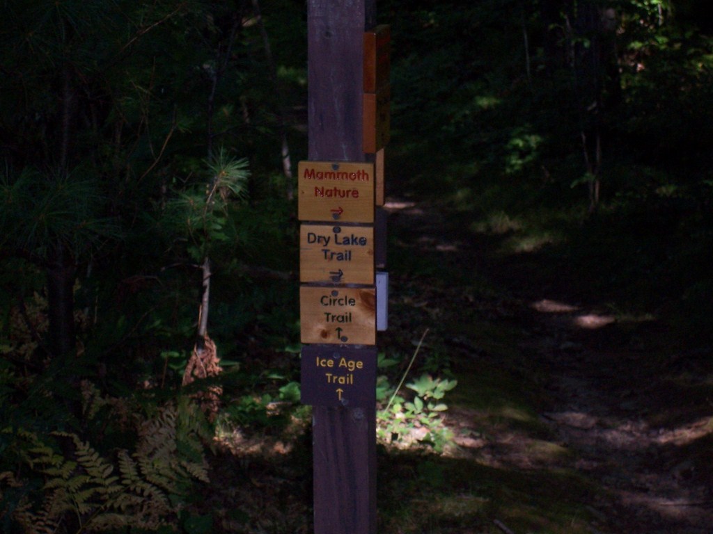
I ran into a couple camping along the Ice Age Trail. They had hiked in from 267th Ave, set up camp for a night with their doggie (a lab of some kind). They were just breaking camp when doggie decided he needed to meet me. Shortly after that I met another couple. They stopped to ask directions. They had walked to the end of the Ice Age Trail at 267th Ave. After a minute or two I was able to get from them what they had intended to hike. Basically, they wanted to hike the Circle Trl starting from the center, heading East. The trail goes in a Circle (hence the... yeah). Trouble was, they started out going West. Got them re-oriented and was somewhat comfortable they knew what direction to go when they hit the intersection.
I hit the intersection about 20 minutes earlier, around 09:56. By 10:25 I made it to 267th Ave. I dropped my pack for a few minutes, drank some tea I'd packed along and took a short break. At this trail head there is a little plaque that describes the history of a stump. Some day this stump will completely rot and fall to nothing. I hope the plaque remains. I'd mentioned summer camp memories of Northern Wisconsin, and this stump is all about that. The stump was once a tree that bowed over the gravel road and was called the Chippewa Bay Tree. This tree grew in an arc over the road and was an important landmark for the kids arriving at Chippewa Bay Camp. The tree was considered the entrance to the camp and is still an important memory for many who are no longer young, except at heart. I'm almost in tears thinking about this and writing it down. I'm verklempt.. talk amongst yourselves... Topic... archealogical reconstructionism.
 |
| Stump on right is what's left of Chippewa Bay Tree |
Good gravy. I'm writing this and listening to Pandora. "Sunshine on My Shoulder." Yeah, wow. You know, I wish that when I was younger I had appreciated his music as I do now. He was gone far too early for me.
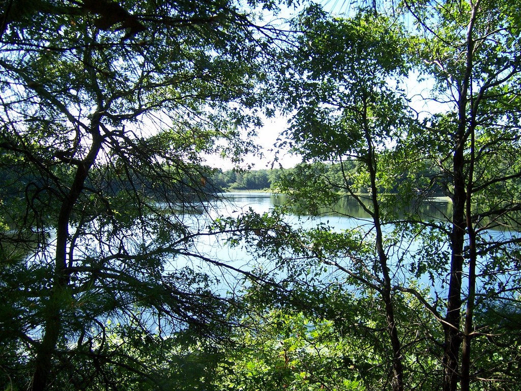
The South Circle Trail runs between a couple lakes and then runs South of North Shattuck Lake. There is also a South Shattuck Lake and a North Of North Shattuck Lake. Check the map. I'm not kidding.
The maps shows there to be no lakes South of the trail for a bit, but there are lakes there. I went through the Circle Trail parking area and crossed Hwy M at 11:05. Shortly after that I spotted a chipmunk on the trail about 30 feet ahead. That's pretty close for chipmunk to let a person near. The chipmunk is my spirit guide. That is yet another Northern Wisconsin story I have. I'm always trying to spot those little critters. I tried for five minutes to get a picture, but he was very good at playing hide and seek.
The trail is a small roller coaster nearly the entire way. Climb 20 feet up, then drop 15, then climb 10, drop 10, climb 30, drop 20. All the while climbing and dropping with peeks of small lakes through the trees. Birdsong in the trees and the wind through the leaves. Yeah, an occasional car, motorcycle, or small airplane too. The trail is in Wisconsin, not Northern Alberta.
 |
| Along the Circle Trail |
At 11:35 I took a break on a bench overlooking another un-named lake. This one appears on the map. (45.213470, -91.416322). I needed a more substantial rest. My legs were getting tight and I'd stumbled a couple times over rocks and roots. I need to get off my feet. At this point I had the woods to myself and sat on the bench, stretched, ate part of a peanut butter sandwich and just took in the view of the lake.
Did I mention that I was having just a great time? |
| Break-time Lake |
 |
| Sunshine on the Circle Trail |
At 12:12 I picked up the Ice Age Trail and immediately ran into two college age guys. They were dropped off at the visitor's center (about a mile up the trail the other way) and were on their way to spend a week on the trail. They'd never really been hiking like this before. They picked a good day for a start and I sure hope they have a couple more days like this before they get hit with rain. We've had an incredibly HOT Summer this year. Temps in the upper 90's and into the 100's were the norm. No rain, except way up North where it flooded. Had they been hiking in those temps they would have been a bit challenged. Maybe not, they're young. We played leapfrog for a little bit as I stopped to take a picture or listen for an animal, but eventually my pace outdistanced theirs. I carried 15 pounds. They carried 40.
Walking along the Eastern shore of Dam Lake I heard a loon call. Once. Then twice, then a third time. The call was not from Dam Lake. I could see most of the lake and the sound was carrying from some other lake. South? East? Could not tell. I stood for a minute or two to try and catch another call, but the concert was over. Three acts.
 |
| The Love Mushroom!! Just sitting in the middle of the trail. |
 |
| Along the Ice Age Trail |
The trail squirts between Horseshoe Lake and a couple of un-named lakes before reaching Town Line Rd. A wooden walkway provides access over drainage between Horseshoe Lake and one of the un-named lakes. The walkway provides a very picturesque view of both lakes. A narrow peninsula that helps make the Horseshoe in the lake looks like a small island from the trail. Frog calls come from the Southern side of the peninsula.
Before reaching this walkway I ran into a two hikers. Naturally, they asked where I was hiking and when I described where I'd parked the woman exclaimed, "So, you're the one!" I was off to bad footing here. Apparently I'd driven up to the boat landing just as the male in the couple had given the all clear for the woman to act like a bear in the woods. She saw me clearly and assumed that I'd seen her. I did not and tried to assure her of that. It was clear she wasn't much in to having me near them. Interestingly though, she is a member of the trail association for that segment and has worked on keeping that very trail clear. She did mention that she enjoyed working on the trail and hearing the stories of the Ice Age thru-hikers (the 1000 milers). I talked with her friend a bit, but it was pretty clear from her that I should move on. Maybe I read something wrong, but I really got the feeling she didn't like me. And me without my light sabre. I saw them one more time and the guy talked to me a bit about water filtration. I'd stopped for a short break on Town Line Rd; just to get the pack off and hydrate a little better. He asked if I'd stopped to get water from the lake and that set off a short conversation on filtration techniques. The guy has hiked in many many places across the country. I stayed a couple minutes ahead of them for the remainder of the hike (a little over a mile) and was packing up when they arrived at the boat landing. I would like to have talked more, but I just got bad vibes from the woman. As I sit here writing I have some regret that I didn't try to engage her in conversation, but you go with what you think you know at the moment.
What I believe to be the most breath-taking spot on the trail is just past Town Line Rd. Crossing Town Line Rd the trail continues up a small wooded hill and then opens up into a ice walled lake plain. The plain sloped from the top of a hill all the way down to Dumke Lake. This late in the season only some of the wildflowers are still in bloom, primarily the goldenrod and aster. Cone flowers were hit hard by the abnormally hot temps this Summer and are pretty much done for the year already. The plain was still stunningly beautiful.
The trail goes through a fence, through a pasture with real moo cows. Then around the North side of Plummer Lake and to the boat landing. All done.
 |
| Dumke Lake and Plain |
Absolutely fantastic hike and my first segment of the Ice Age Trail completed.
GPS say 9.91 miles. Watch says 4h30m.
Thank you SO much for your detailed accounts of Firth Lake, Hardwood Lakes, and Chippewa Moraine segments. I plan to do my first ever solo hike from HWY CC to 267th Ave and back again. My mph is 3.3 with 34lbs so I planned on 6 miles per day, but after reading your accounts perhaps I will cover more ground. I'm somewhat nervous, being an 120lb girl, but now I feel much more confident! Also, please do hike Taylor Co. My ex and I went from HWY 64 to Shady Dr/Fawn Ave. It was very wet, buggy, and rugged, but what beauty lies within that beast!!
ReplyDelete