Welcome

Welcome!
I've been absent from making posts, but the hiking has continued. 2015 is coming to a close and there are many stories to tell from the last two years...

2015
---------
Oh wow. Many many hikes. Ice Age Trail, Colorado, South Dakota Badlands. I need a week off work to do some writing.

2014
----------
July 21st - Sam Baker State Park, Missouri
August - Paddling Door County
Sept 7th - Ice Age Trail - Mondeaux Segment
Oct 3rd - Levis-Trow
Oct 18th - Ice Age Trail - Greenbush Segment

Monday, February 13, 2012

Green Swamp West - Florida


     I had had great misconceptions about the opportunity for hiking in Florida. Even after having read "50 Weird Hikes" by Art Bernstein I still did not quite comprehend the outdoors of Florida. I understood the Everglades, the beaches, the waterways that whorl around coastal islands. I did not appreciate the open country of the Florida swamps. Miami, Ft Lauderdale, Jacksonville, Tampa, Orlando, Ft Meyers cover the landscape of Florida with man made structures, the false nature of golf courses, gardens, and fruit groves, but in between all of these are thousands of acres of swamps and grasslands. I'd never taken a close look at the map of Florida before, but when I did I saw the tracts of green between the scars of silver.


     Probably the last big vacation we'll take for a few years put us in Orlando. No, Disney and the theme parks are not our speed. The Kennedy Space Center was more like it. If you have a single drop of geek blood and have not been to the Space Center, shame on you. Don't wait like I did.

     One of the days, of course, had to be set aside for a hike. I pretty much refuse to go on vacations that don't include hikes in the woods, mountains, or swamps. Based out of Orlando, there are several choices, but the one that seemed to be the most remote within easy driving distance is the Green Swamp Wilderness Preserve of Florida.

     At 110,000 acres Green Swamp the Green Swamp comprises 5 tracts of land including Colton State Park. Fishing, camping, hiking, biking, horse riding, boating, paddling and hunting are the main activities in the Green Swamp. The Florida National Scenic Trail cuts diagonally across the preserve.

     The West Tract (http://www.swfwmd.state.fl.us/recreation/areas/greenswamp-west.html) offered us a good set of hiking trails within just a little over an hour drive from Orlando. We made our way to the Mc Neil Entrance off CR 471. From Orlando take I-4 to exit 32 and take US 98 N. Follow th e highway through populated areas. After some time you'll pass by Central Florida Paintball. Stop if you must, but otherwise keep on the highway. The highway heads sharply Northwest at this point. Just after Gator Creek Campground you'll pass by Rockridge Rd. This also offers some entrances into the Green Swamp, but keep going. Eventually you'll see the signs for CR 471 and a right turn to head straight North. I do mean straight.
After 4 miles a parking lot for Colton State Park will be on the left. Next comes a small bridge crossing and then immediately on the left is the McNeil Entrance to Green Swamp West. The trail starts under the arch, but is riven over by a firebreak. Walk the firebreak South for about 30 feet and the trail heads off into the wooded swamp land.


Lot and Entrance
     This Winter has been nearly devoid of appreciable rainfall in Florida and the results were easy to see in the swamp. The trail and path were very dry. The palm fronds, though green, were tough and sharp. The trail was liberally peppered with dry leaves. Sneaking up on the egrets in the small pond was impossible. Still, not all of them flew away at our approach.
     Within twenty minutes of being on the trail we were treated to different creatures found in the swamp, wild pigs and egrets. The pigs came out of nowhere on the trail Two black spots 15 feet in front of us. Mama and baby stood by the trail for only one or two seconds, long enough for us to figure out what we were looking at. Then they were gone into the low palms that covered the swamp.
The egrets were something we caught out of the corner of our eyes. Just a little bit of white that seemed out of place. About 100ft off the trail was a small pond. On the other side were a dozen or more of these specimens. One my favorite things about paddling the backwaters of the Upper Mississippi are the heron and egrets. Eagles are great. So are owls and hawks, and cardinals, and...


     We briefly caught an owl flying past us later on. Heron made appearances along the way as well. I almost stepped on a toad. Had Stefan not been looking I would have squashed the poor thing hiding under leaves.

     The day was proving to be an excellent one for hiking. The temp topped out around 67F with almost no wind and no clouds. That is right inside my wheelhouse.

     The trail winds along past water holes, many of them bone dry. We kept imagining what animal life would be here in a rainy month. No alligators today.
     The trail crosses a dirt road several times, a few times the trail followed the road. We had to be sure to look for the trail signs as it exited back into the vegetation. The trail was very well marked and at no time on the trail did we wonder which way to go. A little different on the way back, though.

     The trees kept my attention. I didn't really know what kind of trees I was looking at. Clearly some of them were a type of fir, some a type of oak, and yes, ever present are the palms. Often we walked through patches where long white strands of moss draped down large trees. I was simply fascinated by how beautiful these were.


     Almost halfway through the hike we came across three cactus plants growing right by the trail/road. Both plants were small and stayed nearly flat to the ground. They each covered only several inches of the ground. We saw no other cactus anywhere on the trail that day.

     A little more than 3 miles in we hit the "troll" bridge and our turn-around point. We had one kid waiting back at the hotel and it would be dark in three hours. Our plan was to make the bridge and head back. Naturally, my hope would have been for a 12 to 15 mile day in the swamp. Hit the trail at 8am and get off the trail before the sun left the sky. But... had to moderate that desire with other's willingness and the fact I wasn't on vacation alone!! So, back we went. My back was in really bad shape nearly the whole time we were there, especially this day. So, turning back was probably good for me too.


     We re-traced our steps for the first couple miles. At one point we decided to take the road instead for a change-up. The trail crossed the road in several places. We were sure we'd pick up the trail again down the road. We were not patient enough and decided that we must have gone past the last place the road and trail met. Despite having a GPS we were worried about travelling to far South and having to backtrack. With dark only 2 hours away we took a cross road that went directly East. The GPS showed we were still North of the trailhead, so we had no worries. Either this east-bound dirt road would intersect the trail, or we'd hit the highway and half to hoof it for a half mile on pavement. East we went.

     Glad we did. We saw a bit of eco-diversity. On the left side was a swamp that had recently undergone a controlled burn. The right side was the swamp untouched for a few years. Being able to compare the environments close at hand was interesting.
     This road never did intersect the trail. When we hit the highway we were greeted by five foot high barbed fencing. We were also greeted with the firebreak that lead us back to the McNeil lot. Hiking the firebreak was rough going. Basically, a machine comes through and plows up the ground making a five foot wide swath of dirt.

     The total hike was about 6.5 miles, a short one. Still, a great experience of the swamp land of Florida in a pair of boots. I'd certainly go back again, but the hike would have to be longer. Someday.


Sunday, January 15, 2012

First Snowshoe hike of Winter

FINALLY!!! 

     Three days ago we received our first substantial snowfall of the Winter.  This Winter has been brown and dry; November lasting 10 weeks.  Temperatures had at times been in the 50's and 60's.  While some folks liked this I was restless for snow. 
     I used to cross country ski when I was younger.  I may try it again, but I have a feeling my left leg and hip aren't going to be all that good for that.  Downhill ski is something I've only done twice and have no desire to do.  At this point, with my balance and conditioning, I'm sure to break something important.
    Last year I splurged and bought a good pair of snow shoes.  I had them out 6 times last Winter, three of them in the woods around our house.

     That's what I did today.  A little 1 mile-ish loop on a couple of trails right from our backyard.  About 8:15 I hit the snow and walked out into the woods.  About 4 to 6 inches in most places and except for where the neighbors tuned up their snowmobile and another neighbor took the back way home, there were no human made tracks.  The sun was not yet visible as it sits low in the sky and is obscured by the ridges to the South and East, but daylight was full.  About 20F and almost no breeze.

     Besides a hawk and a couple of sporadic twitters, the wildlife was silent.  Tracks were plenty.  Deer, dogs, maybe coyote?, rabbit, mice.  No raccoon tracks today.

     I had to take a 5 minute break and pull briars out of my pants about halfway through. Hooked my right shoe on something, tried to yank it free, but whatever hooked me won that battle and down I went into a patch of undergrowth.
     When I first picked up the shoes I talked to the gal behind the counter about her shoeing experiences.  One thing she mentioned stuck out.  "Expect to fall.  Everybody falls.  You'll fall the first time you're out and many times after that."
     I logged about 8 hours between the first three times I went out.  I hadn't fallen once and I'd not strictly stuck to the trails.  You can't stick to the trails as the trails are typically ski trails.  You shoe on ski trails at your own risk.    You'll leave the woods with a ski pole in at least one orifice.
    Not once did I fall.. until the 4th time out.   The day before the SuperBowl last year Ruth took her skis and I took my shoes.  She skiied the trails and I tromped through the woods.  We figured we'd link up on the prairie after about 45 minutes and parallel each other back to the parking lot.  Just before we were to link up I was climbing a small incline through a stand of pine.  One of the shoes got hooked and I fell forward into the snow and undergrowth.  No big deal, but I really banged my right knee hard.  Wow, that hurt.  Figured I'd have a good bruise from that.
     I met up with Ruth about 5 minutes later to make the last mile back to the lot.  I was definitely hurt.  I was having visions about how purple that large bruise would become.  How swollen.  The pain was about a 6 on the pain scale.  I trudged my way through the rows of corn stalks, falling twice more!!
     Well, figured I'd be off my feet for a day or two.  In reality I had no idea of what was to come.
     Back at the parking lot we stowed our gear and I figured I'd better take a look at the knee.  There was a dime size hole through my outer pants.  Then a dime size hole through my long johns.  Yes, there was a dime size hole in my knee.  Something had stuck right through two layers of pants and into the synovial space between the patella and femur.  "Wow.  Hey Ruth.  We should go to the walk-in."
      The rest of the afternoon was spent at the ER.  X-Ray, wound irrigation, and a shot of antibiotic.  Another pair of crutches.  Wrapped it up and figured I should be good in about 6 to 8 days.
      The next morning the knee looked pretty ugly.  The wound was starting to close, but there was a little bit of red around the wound.  Quite swollen.  I watched the SuperBowl running a 102 temp.  We went into the doctor the next morning.  Short story... massive infection that spread up my entire thigh.  Spent two nights in the hospital and missed a week of work.
     Just one of those things.

     The weeks later I was back in the snow shoes and back on the trail.  And today I fell... again.


Sunday, January 8, 2012

Hills of Onalaska

GPS Track

     January 8th, a rare weekend off for Ruth.  We saddled up the boys and headed to Onalaska to find a couple of geocaches.  Well, we were 1 for 2 on the day.  Couldn't find a micro and we scoured the area.  Cleverlly hidden indeed.

     We've had an odd Winter.  Temperatures in the 50's and 60's.  No snow for Christmas this year, a real bummer.

     This day was in the low 40's and sunny.  Again, a day I'd expect in November, not early January.  Still, it did allow the whole family to get out and slink about a ridge that lies to the East of Onalaska.
     I had always wanted to get out and hike around these hills.  Between highway and commercial area and a residential subdivision lies a 1200ft high ridge that runs about 3/4 North to South and about a half mile West to East.

     The ridge is dotted with several trails and is heavily used by the hundreds of households in the subdivision in the valley.  Trail access is found at the end of Alpine Pl in an empty lot between two houses.  We didn't do so, but in the future I'll consider parking down by the park and walking the extra 1/4 mile.  I can imagine that having a whole pile of cars parking outside your house can be a little bothersome.

     The subdivision is quiet and while on the East side of the ridge the highway sounds are greatly muted.  This makes for a nice little urban escape.

     This ridge was not always so urban.  I came to the La Crosse area in mid 1990.  At that time what is now Apsen Valley was populated with a few houses.  At the end of the valley was a big red barn (which is still there).  Beyond the barn was corn, hills, and trees.
      Today, the view to the West of the ridge is a great view of Menards, subdivisions, and finally the Mississippi.   In 1990 Menards was not there and only half the houses between the ridge and river were there.

     A real history lesson comes from my wife Ruth.  She grew up a mile from these hills.  Many hours were spent in the hills and valleys that are now homes and businesses.  She hadn't been back in these hills since her childhood, decades ago.  There were few houses between the ridge downtown Onalaska.  There were only a handful of homes at the South end of the Valley.  That area was square miles of swamp, hills, and forest.  Ruth spent her free time hiding in the caves, making campfires, and just wandering the woods.


Friday, December 23, 2011

Early Winter

   
LUKE 2:10 And the angel said to them, “Fear not, for behold, I bring you good news of great joy that will be for all the people
     At 0630 the dogs took care of their business as I watched the last of the stars.  A crisp clear morning in late December.
     After taking care of dogs, cat, and wife's coffee the German Shepher and I set out for a short walk behind the house.  The woods were a jumble of brown and white.  A light covering of white on a carpet of oak leaves.
     Many people who live up here come to despise winter by the time they are middle age.  I know that some day I'll leave four seasons behind for two or three and I will sorely miss this harshest of them.
     The woods in Winter are quiet; a sharp silence broken only by your own careless footsteps and the crunch of snow and leaves.  Some claim they cannot stand that silence but they are not listening to the sound that is there.  Not just the footfalls and leaves, but your own thoughts.  Whether good or bad they wait for Winter, for your attention and reflection.

     At 0700 the sky was a timid gray but within minutes the first colors of dawn were streaking over the ridge.  The Eastern sky worked it's way through a rainbow of purple, magenta, red, and amber and soon the entire circumference of the horizon was banded in pink.  The East was on fire with orange, amber, purple.  Some time would have to pass, an hour or more before the disc itself would peek over the ridge.  As it turned out the clouds took over for a part of the day.

    Winter sunrises seem to have more color to them than any other season.  There is a reward for braving the cold and watching the day come to life. 
     My first wife and I used to live in Stoddard.  Our apartment was on a road that lead out of the small village and into a coulee that contained great character.  One Winter morning when I wasn't able to sleep I went for a walk down the road, and up on the first hill watched a sunrise like I'd not seen before.  One very much like today's.

     Another notable event on that road occurred one September afternoon.  I'd been putting in long hours at work and took a rare afternoon off.  A mile on down the road I dipped into the coulee and around the bend came to a stop.  50 yards ahead was woman with a shotgun standing across the road from cows in a field.  This is not the most unusual thing you are likely to see in the Upper Midwest, but still something to warrant caution.  Eventually she noticed me and carefully waved me over.  I carefully walked over to her.  In the field across the road there was a fox in the middle of her cows.  That fox, though, could not have cared less about the cows.  She was rolling around in the trampled grass enjoying the cool sunshine of late September.  After about 15 minutes or wordlessly watching her, the fox pranced up the rise and into the woods.

    Winter is here and hopefully some more snow.  The snowshoes are just itching to get used.  I have the next week off and have started thinking about a hike.  Maybe Devil's Lake again and finally get to Parfrey's Glen. 

     Merry Christmas!!

Sunday, December 4, 2011

Tokyo - Takao-san to Jimba-san

     December 2011 and I find myself back in Tokyo.  I made it out here last year, a work trip, and this year, work again.  Someday I hope to come out here and not have to work at all.
     If you’ve read any of my other postings you’ll understand that I am not a fan of crowds.  What I consider a crowd, in Tokyo, is considered a small gathering of people.  The train station in Tachikawa, a westerly suburb of Tokyo, services over 170,000 people a day.  The closer the station is to Tokyo, the larger that number grows.  On a Sunday morning at 07:12 the Tachikawa station has over 1500 people waiting for trains and at least that number getting off the trains.

     That’s where I was on Sunday December 4th, 2011; at Tachikawa station waiting for the train to Takao.  The 07:12 arrived at 07:12 and left at 07:14.  Arriving at Takao station about 15 minutes later, you jump off the train and find your way to Keio line and the train to Takao-sanguchi.  Six minutes later the train shows up, you board, and 1 minute later off you go.  3 minutes later the train arrives.  I love the Tokyo train system.  The trip costs about $2.00, even with the exchange rate of the miserable US dollar.  I really love the Tokyo train system.

     The original plan was to hike up to the summit of Takao-san on trail #6 and then back down on one of the other trails, #1 or #4, maybe.  The website (http://www.takaotozan.co.jp/takaotozan_eng1/index.htm) states that the ascent is 90 minutes and the descent about 70 minutes.  I was looking for a 5 to 6 hour hike.  This was a little short, but my research to that point made other peaks a bit out of reach, or so I thought.
     Another plan was to take the train to Fujiino station, hike up to Jimba-san, and then hike back down to Sagami-ko station.  That trip, as described on another website (http://www.tokyoactive.com/hikemaplistD.html) would take 6 to 7 hours.  The distances described seem to make this a reasonable time estimate.

     I was in a quandary.  The sun goes down at 16:30.  I can get on the trail at Jinba-san by around 8:00.  I’m not going to wake up at 05:00 to make a very early train.  Just not worth it to me.  Maybe? 
     After talking with a couple locals, non-hikers, who had been to Takao-san, they assured me that Takao-san would be challenging enough to take 4 or 5 hours.  Okay, Takao-san it is.

     Thursday, Friday, and Saturday were miserable, cold, and rainy.   7C and raining, drizzling, steady rain, then high wind.  No way was I going to hike on Saturday.  Well, I would have, but Sunday promised to be a spectacular day.  I did go walking around Tachikawa on Saturday morning and afternoon, but got absolutely soaked.  After the 5.3 earthquake woke me up I needed something to do other than sit in the hotel.  So, I walked in the rain. Prayed at a Buddhist temple, and got very very wet and cold.
     I also decided, after reviewing some more information that I was going to at least attempt to go beyond Takao-san and reach the next summit, Kobotoke-Shiroyama.  A trail from that summit lead down to Sagami-ko and the whole thing should take about 4 hours.  Good.  That’s the new plan.

     Sunday, dawn, 06:15.  I was up already and packing gear that I’d laid out the night before.  The day was forecast to be very sunny, 0% chance of rain, and highs around 15C.  Figured that at 700m, the temp would probably be closer to 10C, so pack a little warmer.  I also have to pack light.  I do very well in the cooler temps and not so well in the very hot (30C and above).  I just run hot I guess.  I made sure to pack enough food and water for 7 hours on the trail.

     Right outside Takao-sanguchi station is a large map of Takao-san and the trails.  The website gives directions from the station to the trails.  I found the directions next to useless.
Takao-san map outside Takao-sanguchi
      Tip #1 – stand facing the map.  Turn to your right and walk up the road.  The first trail is the Inariyama trail.  It is on the left side of the paved road you will be walking on.  There is a wooden post right at the trail head with the name of the trail on it.  Oh, the name is written only in Japanese.  Did I mention that I speak, read, and write absolutely no Japanese?  Yeah, tip #2 – memorize the first two Japanese characters for the important points along the way.  Half of the sign-posts on the trails are in Japanese only.  Unless you are one of those very rare breed who can find their way through a corn maze on cloudy night with nothing but a toothpick and candy bar, you will get lost on the Japanese mountain trails without being able to spot the name of your destination on the sign posts.  Well, you won’t get lost, but you’ll have to ask for help.  Your chances are about 40% of getting someone that speaks enough English to communicate.  Then, you need to be able to communicate where you need to go to them.  My oh my, can that be interesting.  I continually have the Japanese apologize for not being able to speak English.  Bless them.  I’m in Japan and I don’t speak Japanese.  What should I expect?

     Trail #6 is just another 200m past the Inariyama trail and is likewise on the left side of the road.  Good news!  In amongst all the Japanese on the sign post is a big ol’ “6”.   I marked the trail head at 08:00 right t on the button.  I like being on the trail no later than 08:00, especially in the winter hours.  Perfect.
Trailhead for Trail #6 - Translates to "Nature Inspection Road #6"
     As soon as you hit the trail you are in the woods and climbing.  Actually, the road climbs slightly from the train station.  Also once on the trail and in the woods, the temp drops.  I didn’t have a measurement, but I would guess no warmer than 5C.  I was wearing my orange knit cap, a light poly-nylon running long-sleeve and a poly-spandex short sleeve under that.  Lightweight hiking pants, socks, boots round out the worn clothing.  The gloves were in the pack and I nearly brought them out.  After about 20 minutes on the trail the fingers were ok.  After 40 minutes on the trail, the hat came off, then went back on.  Then came off again.  You get the idea.  Cold, warm, cold, warm.  Like I said, I run hot.
     I especially run hot when climbing.  The trail climbs 150m in 3.3km.  There was really only one point where the trail was remotely challenging for a climb.  About maybe 1200m from the summit there is about 400m worth of stairs (wooden ties sunk into the dirt and rock of the trail).  I hate stairs.  I think most hikers do.  But, without these stairs the trail would long have washed into the valley below.  This was a pretty steep climb that lasted about 5 or 6 minutes.  Not terrible, but some serious work for that short period.  The trail runners practically flew up the grade.  I used to be that nimble once!  Dang ‘em.
     Along the way, before reaching the Stairs, you’ll pass by the Biwa waterfall and shrine.  Be sure to take the short side trail and spend 30seconds looking that shrine and waterfall.  Before the stairs, the trail also turns and goes up a rocky stream bed.  The trail to that point has been a mix of slipper rock and mud after three days of solid rain.  The stream bed is all rock, very slippery.  The water pools are only a few inches deep, but are just enough to catch a foot and twist.  I tweaked my right calf at one point on that stretch.  I felt it go and thought “Holy crap.  That’s then end of my day.”  Kept walking though, and kept climbing.  By the time I’d reached the second peak… no problem.

Biwa shrine and waterfall
Trail climbs a stream bed
     At the top of the stairs is a major trail junction for the Takao trails.  There are also benches.  The timing was right and I was pooped from the stairs, the stairs, and the stairs.  This was a good opportunity for a five minute break.  Tip #3 – unless you are totally spent, don’t stop here.  You are a short easy climb of three minutes from the summit. Wait for it.
     There are four ways to go at the junction:  from whence you came, to the left, to the right, and straight up.  Straight up is the way to summit.  To the left circumvents the summit and heads to the next peak on the trail.  The path to the right goes back down on Trail #5.  Go straight up.  This is a grooved concrete path, the first pavement since the road from the station.  The climb is easy and within minutes you are at the summit.  On this clear sunny day like this day, Fuji-san is in-your-face.  Simply outstanding.

Hi There!
Fuji-san
   The summit is packed with people.  Most folks take the cable cars up to the summit and then hike back down.  There are souvenir shops and noodle shops, tables, benches, vistas all over the summit.  Pretty much what I expected to see from what I had heard.  People. 
     Again, if you’ve read my posts, I look for solitude on my hikes. In the mountains near Tokyo, you are not going to get that.  I was very lucky last year and went to a lesser travelled peak on a lousy weather day.  Today was one of the most popular peaks on a gorgeous day after a week of rainy weather.  At no point along the entire trail for the whole day was I alone.  The furthest distance between me and another hiker was later in the day and was about 30m.  Most of the time I was at least within 2 or 3m of somebody.  I tried to keep my distance so as not to push or disturb anyone.  Several times I found myself nearly in lock-step with another hiker or two.  We never said anything to each other, each keeping our own peace, but each other’s pace.
     By 09:08 I was at the summit.  That 90minutes took only an hour.  I now went to plan C, or was it D.

     Jimba-san was my new goal.  The sign post said Jinba-san was 5 hours and 18.5km away.  I’m not a strong climber, but I’m a steady climber.  Two more summits before Jinba-san, 4km per hour if I’m feeling good (and I was).  Jinba-san was the new goal.  The hard part would be the trip down to the bus stop and Jinbakogenshita village.  There is also a bus stop at the Wada village, which would have been shorter, but I wasn’t certain about the trail, or the bus stop.  But down to Jinbakogenshita village was another 2.5km according to one knowledgeable hiker I talked to.  Keep that number in your head for later. 

     I stopped and ate one my ongiri.  Rice shaped in a triangle, stuffed with something, sometimes fish, sometimes bean, sometimes something I don’t know, wrapped in seaweed.  I love these things.  They are easy to digest, cheap to buy, and just hit the spot.  Had one of those, some nuts, drank some water, took some pictures and hit the trail.   09:20 and I’m off to Kobotoke-Shiroyama and 670m.


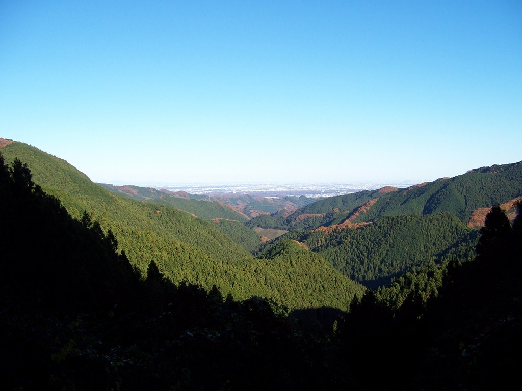
     Immediately from Takao-san there is a sharp descent, and yes, stairs.  Slippery muddy stairs.  The rest of the 40 minute hike to Kobotoke-Shiroyama rolls gently up along the ridge, alternating between cypress forest, and mountain prairie.  The trail also sports a few sightings of Fuji-san, but even more spectacular is the view of the other side of the ridge.  Peaks and trees spread all the way to the horizon.
     All along the entire ridge between Takao-san Jimba-san you can hear the sounds of life below.  The Chuo Expressway and trains are all a constant hum while on the ridge.  Occasionally, you can spot them below.
     At 10:00 on the dot I made the summit to Kobotoke-Shiroyama at 670m.  I took the pack off, stretched, nibbled on some nuts and wasabi crackers, and drank some more tea I brought with. Excellent views of Fuji-san.  At 10:15 I was back on the trail.


     Very shortly after the summit a long descent begins.  Yes, there are stairs, but not nearly as many.  Mostly there are just footholds in the mud.  The trail drops steeply and is very slippery.  I felt sorry for the people travelling up.  I shouldn’t have.  Twenty minutes later there is a 15 minute climb from Hell.  Yes, stairs.  That whole distance we descended, plus another 50m up was necessary to climb to reach Kagenboru-san  at 727m.
     Along the way up there was a pack of 10 or 12 of us that got stuck going one-step-at-a-time up the long ascent.  My calves just simply could not go that slow, so I found a spot to the side of the trail and scrambled as quickly as my stiff body would go past the whole crowd.  At the front of the conga line was a lady who must have been in her 70’s or 80’s.  She was with her retinue of what was likely her daughter and grand-daughter.  She was climbing this one-step-at-a-time.  Although moving  very slowly  she was going to make her way to the summit. Wow, that’s what I say.  I felt embarrassed for having skipped in front of her.  My only other two choices would have been strained calf muscles of stop and wait the 40 minutes for her to make the summit.
     That climb from the saddle to the summit of Kagenboru-san is, by far, the toughest climb of that route.  Going the other direction I would suppose the saddle to Kobotoke-Shiroyama would be the toughest.  That was truly a challenge, but I’ve done much harder.  Along the steep and winding switchbacks the view opens up several times to give views of the Tokyo basin below.

     At the summit of Kagenboru-san is a basically a picnic area with soba shops and picnic tables… and incredible views of Fuji-san, the Sagami valley, and Tokyo basin.  People hike up from below and bring in camp stoves.  They cook their own noodles or buy them from the noodle shops right at the summit.  I’ve never seen anything quite like it.  At 11:15 we all found ourselves at 727m.

Kagenboru-san
    In the picture of the summit you’ll see a guy with a face mask under his chin.  For those of you who are not familiar with Japan, this is not because the air is so polluted.  He wears this, or should be wearing it, because HE’S polluted.  He has a cold, the sniffles.  In Japan, when you have a cold, you wear a face mask until goes away.  Not the law, just what you do.  What you’re expected to do.  Not sure how much it matters.  Just like every other human in the world, the people of Japan pick their nose (yes, I saw you do it!  You tried to be sneaky, but I saw it!), rub their eyes, pick at the corners of their mouths. 

     I was really feeling dehydrated at this point and took stock of my water.  I had enough for about three more hours.  Just water was left.  The sugary tea was gone.  I went to the noodle shop and bought a bottle of Lemon C-C and a small bowl of miso soup.  Told myself I wasn’t going to do that, but when in Rome…
    The soup was the worst miso I’ve had and I like miso soup.  I  was glad I only go the small bowl.  I drank the 100ml of Lemon Water in nearly a single swallow.  Ate a Snicker bar, had another ongiri (I LOVE those things!).  I brought three with.  I was pretty pooped out and my legs needed the break.  The Lemon stuff and soup worked their magic and a couple of good stretches had me ready to go. 
     11:45 – 5.7km to Jimba-san.
Jimba-san 5.7km
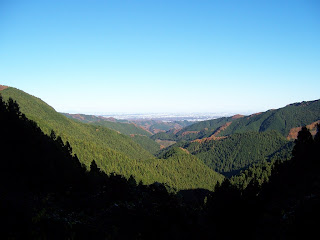
     The trail from Kagenboru-san to Jimba-san rolls up and down the ridge.  There is no large descent, no large ascent.  A little down, a little more up was the course of the trail.  Along the way are views of the valleys on both sides of the ridge.  Occasionally, Fuji-san peaks into view, but by now an early haze has come in and the distant peaks are visible, but lack detail.  The trail is smooth, unpaved, wide, and fast as it rolls through the cypress forests.  The wooded path reminded me of running along the forest paths at scout camp in Northern Wisconsin.

Valley to the Norhwest of the ridge

     I mentioned before that there were people that I’d fall in step with or they with me.  We hiked as individuals, but keeping the same pace.  I don’t understand why, I’m sure there is a good explanation, but the fashion with Japanese hikers to attach bells to their packs.  Jingle, jingle, all the way. In the US we do that to let the bears know a tasty morsel is coming near, like an ice cream truck in a suburban neighborhood.
     There are no man eating creatures in the Tokyo mountains.  There was one guy I fell in with just after Kobotoke, on the descent out of Kobotoke.  He was a jingler.  Jingler-san I named him.  His pace was nearly identical to my pace.  We stopped at the same rest stops and without trying we were within meters of each other.  He was faster on the descents, I was steadier on the climbs. 
     We hit the last rest stop before Jimba-san at 12:40 (738m).  Ten minutes later, he started to go and walked right by me and slowed down.  I happened to be looking up and caught him looking back  at me.  His eyes and set of his face said, “So, are you coming?”  I stood up, he turned his head and off we went, without a word.    About 10 minutes after that rest stop his pace slackened significantly.  Whether he was tired or knew something I didn’t I couldn’t be sure.  With a “musimesen and origato” I left Jingler-san to summit Jimba-san on his own.  The last approach to Jimba-san looks daunting, but it’s really not very difficult.  You can hear the people on the summit from 400m away.  At 13:23 I was at the white horse and the summit of Jimba-san.  I had been on the trail for 5h23m and 4h12m from Takao-san summit.

     The summit is a large open meadow.  There are three different noodle shop areas on the three different levels of the meadow.  The views at Kagenboru-san were fantastic. The views at Jimba-san are without expression.  Three old men were down on the side of the slope using a broom to get the last few apples off an apple tree.  The slope was steep and the one with the broom would have to jump and swat.  He’d land and slip and roll down the slope, knocking one or both of the “grabbers” off their feet.  I had almost as much fun watching them as they were having themselves.  On one of the side levels someone brought out a guitar and he and group of hikers started singing some Japanese folk song.
Jimba-san, one of the levels
    I sat down on a bench in the sun and listened.  Decided the sun was not very warm and put the long sleeve running top back on (that came off at Takao-san).  I listened for a while to a song  I did not know, nibbled on my remaining food, and drank most of my remaining water.
     Recall that a knowledgeable hiker related to me that Jinbakogenshita bus-stop was 2.5km from Jimba-san.  If you were to go down the trail to Wada pass and then the road to Jinbakogenshita and stop after 2.5km you’d still be 1.9km up the side of the mountain.  The sign said Jinbakogenshita 4.4km at the Jimba-san summit.  There was yet over an hour to go.  14 ounces of water left.  No problem.

     At 13:48 the descent to Wada Pass begins.  1.1km of mud and roots.  I discovered how many people arrive at Jimba-san so late in the day.  There is a parking lot at Wada pass with enough room for maybe 15 cars.  Somehow seems like cheating!  Now there remained 3.3km of pavement; all downhill.  I somehow seem to find a way to end my hikes with 2 to 3 miles of pavement.  Good gravy.
     The views along the mountain road were splendid.  The road was narrow, wet, and steep.  A lightly  travelled road by Tokyo standards.  There was perhaps a vehicle of two every 5 minutes.    I passed by two different groups of hikers along the way. They were headed to make the bus just as I was.  I made the bus,  They would not be that fortunate.  At 14:45 exactly I came into view of Jinbakogenshita.  In the middle of the road was a uniformed man yelling into a bull horn in my direction.  Although speaking in Japanese I got the idea… “the bus is leaving now.”  I lamely jogged the last 300m, asked quickly.. “Takao station?”  “Hai, Takao!”.  On the bus and off the mountain…


     I do not know if I ever will get back to Japan.  I’ve been very fortunate the last few years to have been able to travel to a few places for my work.  I’d never had made to these places on my own.  I’d also thought that I’d be able to take trips like this every couple years, but the realities of where I find myself make that impractical if not impossible.  Fortune smiled greatly on me by having me work where I do and doing what I do.

     Japan is great land of history and culture.  I’ve touched the surface and not even that.  My passion for hiking and mountains has taken me away from museums and other such things where I would have picked up much more detail on the culture, but I’ve no regrets.  While in Japan these last two trips I’ve done the work that I love and have been to the top of 6 minor peaks in a land that most will never set foot on.  I consider myself extraordinarily blessed to have been here and set foot on the rocks and dirt of this country. 

     Thanks to Jingler-san for the company and I wish you many more pleasant hikes.

Approximately 26.2km in 6h45m.  Trail notes below:


07:48  Arrive at Takao-sanguchi station
08:00  Traihead for Trail #6
     45deg   Sunny but damp
08:10  Biwa waterfall and shrine
08:45 Trail Jct
     Trail goes up a stream bed
08:55  Short break
     Trail Jct with trail #5.   Climbed 400m of stairs.  Difficult climb.
09:08  Back on the trail.
09:11  Takao-san Summit  599m
09:20  Towards Jimba-san
09:47  Great viewpoint
10:00  Kobotoke-Shiroyama Summit 670m
10:15 Off again
10:20  Very slippery and muddy descent
10:45  Climbing steep and sharp switchbacks
11:15  Summit  Kagenboru-san  727m
11:45  Start for Jimba-san  3.5km away
12:07  Hiking rolling ridge
12:33  2.3km to Jimba-san
12:40  Rest stop at 738.9m  2.0km from Jimba-san
12:50  Off again
13:23  Jimba-san Summit  857m
13:48  Off again – 4.4km to bus top
14:03  Arrive at parking lot.  All pavement for the next 3.3km
14:45  Made bus seconds before it was going to pull away


Sunday, November 6, 2011

Wildcat Mountain State Park - Wisconsin

November is one of my favorite times to hike in Wisconsin.  Also one of the more difficult times to hike.  The leaves are almost completely gone.  The trees are dark, the grass is brown, the sky is gray.  The combination can lull you to sleep in the parking lot.  At time you must rub your eyes to keep them from crossing.  The whole of the world is muted.  There is a beauty in that scenery that many try to deny.  With the leaves on the ground and the grasses, thorns, bushes fallen as well, the lay of the land is visible in a way that was not possible only a couple weeks ago.  The forest vegetation has given way to the land itself.  Now visible are the rocks, logs, streams, but more importantly, the ridges, the draws, the hills.  This is not the same forest you were in back in August.

November begins hunting season.  Once a hunter, but not now, I completely agree with the practice of hunting.  I understand the need for people to commune with nature by harvesting, killing.  I mean no sarcasm here.  That is simply what is in nearly all of us.  I very much agree with the conservation benefits of hunting.  A discussion I'll not have here.   The downside is that almost all public land is given over to hunting from late October through mid-January.  During the bow seasons I do not worry so much about being shot.  Bow hunters are generally careful people who truly know how to take care of their woodlands.  I do worry about spoiling their hunt by walking around scattering their game.  I've had bow hunters tell me that I'm doing them a favor by making the deer leave their bed.  I've yet to take that to heart.   Gun hunting is a whole different story.  I have been gun hunting and I know what kind of people are out there.  Many are just as respectable as bow hunters, but a certain percentage have no business A. being in the woods B. carrying a weapon.  Foolish, careless, and deadly dangerous.   There are places to hike but they must be picked carefully.  Wear orange and understand how to interpret the report of a discharge.

November is a tricky month for weather.  Day-time high temps can be anywhere from 80F to 10F.  Rain, snow, sleet, sun, wind are all possible and in the same day.

I like hiking in November.  Good times.

Wildcat Mtn is yet another little gem in Wisconsin.  Situated in the coulee country of Western Wisconsin Wildcat offers some challenging terrain.  The town of Ontario lies just outside the park and boasts itself the Canoe Capital of the Kickapoo.  I cannot disagree with the claim.  During the Summer, canoeing the Kickapoo is big business and a whole lotta fun.  The Kickapoo is a lazy, shallow river with many bends, travelling through swamps and ringed by high bluffs.  I tried to get Ruth to go paddling on the Kickapoo a couple times this Summer, but she is resistant for some reason.  I'm not aware of any legendary river monsters on the Kickapoo so I don't think that's it.

http://dnr.wi.gov/org/land/parks/specific/wildcat/

The highway from Ontario to the Park is a steep twisting climb.  Some folks think they can far exceed the 25MPH limit and to them I say "Good Luck and don't try it when I'm on the same road!"

The plan for the hike was to park in the upper picnic area and take the Old Settler's Trail in reverse (clockwise).  At the halfway point pick up the Red Loop Horse trail and take it counter-clockwise.  Then, pick up the other half of the Old Settler's trail back to the upper picnic area.  The total distance would be right around 8.0 miles.  I planned for between 3.5 and 4.0 hours. 

I made the parking lot at 08:40 and was on the trail by 08:46.  The drive over saw the sky a mix of sun and clouds.  Low, dark gray, menacing clouds.  Temperature somewhere around 45F to 50F.  As I hit the trail the sky was a very dark gray, threatening rain at any minute.  The wind was gusting, probably around 15mph.  A wonderfully dreary November day.  I had my rain jacket packed at the top of the pack.  I was pretty sure I was going to need it soon.

Old Settler's Trail Head


The trail from the picnic area to the split of the trail loop is a steep downhill.  That means an uphill to finish the hike.... hooray!  :=P   Taking a left at the split the trail rolls along a ridge for a bit before descending to the bottom of a hollow and crossing a stream.  A large stand of Norway pine, planted back in 1951-52, made for some interesting backdrop.  The sky was drab, dreary, menacing.  The pine forest was very quiet, even the wind wasn't making much noise, but the trees... Groans and creaks that did not even sound like trees.  Popping and grinding as live pine strained against holding up a dead neighbor made for a very eery path.  Walking this part of the trail in the dark on Halloween would end up putting some people into therapy.

Bridge after Haunted Pines


After a long, steady, rolling climb to the top of a ridge there was a side trail that dipped down the other side.  The Old Settler's trail continues on up the ridge to Taylor Hollow overlook.  I decided to go down the side trail for a little bit.  The trail quickly makes the short descent to the bottom of the hollow and into a pine forest.  Within a couple minutes in the pine forest the trail had gone from groomed, to used, to barely discernible, to where the heck am I going.  Turned around and went back to the main trail.  Past the overlook the trail comes to the park office, the ampitheater, and weather station.

My back and left hip had been bothering me after I woke up.  Not a good back and leg day.  I very much needed to drop my pack and did so at the ampitheater.  Took off my quick dry sweatshirt and hung it to dry in the wind.  Had some water and stretched for about 10 minutes.

There is a mowed field across the gravel road from the ampitheater.  That field contains the weather station but a couple of XC ski trails cross there as does the Red Loop horse trail.  Not for me, though.  I had it in my head to go up the gravel road towards the group campsite and pick up the Red Loop from there.  That simply brought me right back past the weather station.  I waved to the Park office building as I went by.  There wasn't anyone there, but it still seemed appropriate.

Right after the field the Red Loop ducks into the woods and drops down to wind along about half way down a slope.  There are a few parcels of private land inside the park boundaries.  At this part of the trail and just below the trail was one of those posted private lands.  Be sure to stay on the trail, especially during hunting season.  There is plenty of park and no need to drop down and explore that land.

The wind was very interesting.  Although early November and temps well above freezing the wind simply cried out "Winter."  November is such an interesting month.
Another item that needs consideration is that this is a horse trail.  There are only a couple of true hiking trails in the park and the Old Settlers trail is the longest of them at 2.5 miles.  If you are going to put on some more serious miles you'll need to take the horse trails.  Our equine friends can produce a prodigious amount of waste product.  What I mean to say is that the poop.  They poop large amounts and do so frequently.   Hiking on horse trails occassionally requires some agile footwork.   The other thing to keep in mind is that while the riders are typically looking out for other animals, including people, the horses may not be.  I've had horses get spooked when I was sure they must have seen me.  I'd been talking to their riders and still the horse had no idea where I was until right next to me.  Watch, listen, and give way early.

The part of the Red Loop between the park office and the junction with the Blue Trail mostly runs along the side of a bowl made by two ridges.  There is section of about 200meters where the trail follows along just below the ridge where the entire top of the ridge is exposed sandstone bluffs.  The trail then crosses a saddle and drops down to follow the other side of the ridge.


The Green, Red, and Blue Loop trails all meet up in one spot and branch off in different directions.   For quite a distance the Red and Blue tag-along on the same route.  At one point, before the Blue Loop heads down and across County Road F, the trail drops down into a bowl and follows the outside of a grand prairie with a small stream.


There is a bit of a climb up after the split the Blue and Red Loop trails.  A gradual, long, suprising climb.  About 3/4 of the way up you finally realize that you've been working pretty dang hard.
Another good climb comes just after the Red Loop trail passes the horse campground.  I was pretty beat at that point and that climb was not the most welcome.  Well, that's one of the reasons I'm out there.  Push things just a little bit.

I took quite a long break up at the group campground.  Despite the temp being only around 50F I took off my socks to let my feet cool down and dry.  Changed socks before I left.  I'd already had a short lunch break after the first climb mentioned, so no food.  Didn't need it.  Dried out the quick dry shirts, stretched the legs and laid down on the picnic table for about 15 minutes and close my eyes.  I suppose I should have been cold, but that just didn't register.

The group campground was the end of the Red Loop for me.  I followed the gravel road back to the Park Office area and picked up the last half of the Old Settler's trail.

Along the Red Loop I'd met two different groups of riders.  Met the same groups twice.  Stopped for about two minutes and talked with one group.  The lead of the group asked me the name of this blog and for Pete's sake... I couldn't remember!!!!  Bad stuff.  Boy, the grin he gave me...
The lady in the group made a good comment.  She said, "don't tell too much.  Wildcat is our little secret."  That is an issue isn't it.  Another point that the lead rider made was that the trails, years ago, were very narrow and not generally maintained.  In the last several years the DNR has widened the trails, put down significant amounts of gravel.  The idea, apparently, is to be able to drive their 4 wheelers along the trail to make maintenance easier.  I guess if we want our trails narrow and dirty we will all have to be able to put in far more volunteer time.  The DNR gets stuck between a budget and a hard place.  If you'd read my post on Devil's Lake State Park you'll know my dislike for paved trails.  The trails at Wildcat are not paved, but for how long?

I met three couples along the last mile and half of the Old Settler's trail.  One had a couple fun-loving dogs.  We shared war stories on old and sick dogs.  The trail, the way I was going, went down a pretty significant grade.  All three groups asked me "how much farther", as they were climbing up while I was going down  -  Only a few minutes folks.  The climb back up really wasn't very noticeable until after the junction.  Then, as mentioned at the start, the climb to the upper picnic loop is a real climb, but is very short as well.

Old Settlers Trail below Wildcat Mtn.
I made the parking lot by 13:00.  4 hours and 18 minutes after starting.  No rain and the sun actually tried a few times to make it out.

These are the little notes I took along the way to keep track of where I was and when:
08:36 - Upper picnic windy, rain threat 45F
08:42 - on the trail
08:49 - Loop junction
09:00 - groaning trees in pine forest
09:02 - bridge over creek
09:09 - trail down to pine forest (wrong way)
09:28 - trail to park office
09:30 - ampitheater, break
09:40 - break over
09:48 - Red Loop trail
09:55 - Weather station
10:06 - 200m bluff ridge
10:13 - cross saddle
10:20 - Hollow bottom; babbling stream
10:26 - other side of bottom
10:28 - Red/Green/Blue jct;  break
10:36 - Off again
10:52 - top of ridge; big climb
           Lunch  PB sandwich, Pepsi
11:08 - off again
11:18 - Blue Loop split
11:24 - Finished another climb!
11:28 - Rock Johnson Loop junction
11:43 - Horse campground
12:00 - Group campground - big climb
           Break
           Sun trying to break through
12:20 - Off again
12:32 - Park Office, Old Settlers trail
13:00 - Upper Picnic